
Travel Blog February 25 to March 22, 2026Vancouver, B.C., Canada to Antarctica via Chile, the Falkland Islands, South Georgia and South OrkneysWednesday, February 25 to Thursday, February 26, 2026: Vancouver (49.2827° N, 123.1207° W) to Santiago de Chile (33.4489° S, 70.6693° W) via Toronto
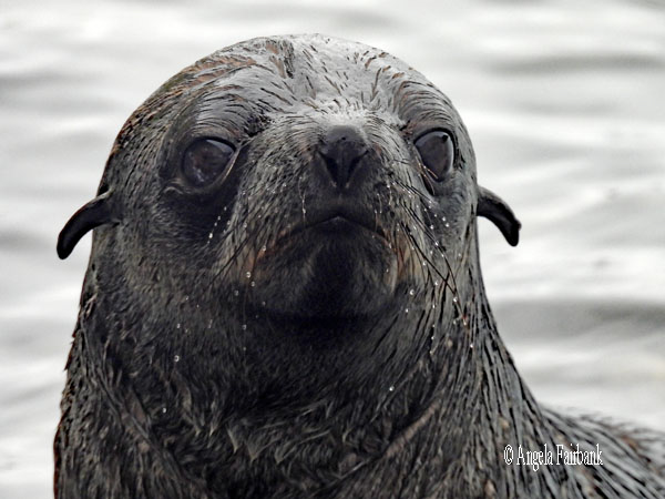
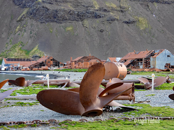
I booked this trip on board Hurtigruten Expeditions (HX)'s MS Fram while I was circumnavigating the archipelago of Svalbard in Norway from June 23 to July 6, 2025. I did so, not because I would be introduced to a new United Nations' country, unfortunately, but because I felt I had not thoroughly completed South America by not having visited either the Falkland Islands (Las Malvinas) or South Georgia, both British Overseas Territories and on many world travellers' lists. So here I was, back on a plane, leaving about 11-degree-Celsius weather, travelling east to Toronto, waiting about five hours in the Air Canada lounge at Pearson airport, and then in business class (using some of my e-upgrade points) south to Santiago de Chile. As usual, I slept, I ate a couple of meals, and I watched the screen, this time a few episodes of an HBO series called The Pitt set in the emergency department of a hospital. I arrived without incident in Santiago and walked with my collected luggage to the airport hotel, a Holiday Inn, in about 29-degree-Celsius weather. After checking in, I worked on a book translation, and got an early night after eating some snacks from home that I had packed in my luggage, and tried to watch a Netflix series, although I was unable to keep my eyes open. Friday, February 27, 2026: Santiago de Chile After waking up, eating a simple, included breakfast at the hotel, and requesting a 'late' checkout at 12 noon, I continued working on my translation until that time, checked out, and ordered an official taxi to take me to the Las Condes section of downtown Santiago, where I checked into the HX hospital desk at the Hyatt Centric hotel. As my hotel room wasn't yet available, I worked some more on my translation on my laptop in the hotel lobby until my room key was provided to me at about 3:30 p.m. By about 5:30 p.m. I had completed a draft of the first chapter and sent it off to the author as arranged. Then, as we were scheduled to depart VERY early the following morning, I ate a snack or two from my suitcase and got an early night, although, unfortunately, I did not manage to sleep much. Saturday, February 28, 2026: Santiago - Punta Arenas, Chile (53.1634° S, 70.9077° W) After my alarm went off at 3:00 a.m. (yes!) I took a quick shower and headed downstairs with my luggage to check out of my room, grab a few breakfast items to put into a paper bag with handles, pour myself a paper cup of hot coffee, and sit in the lobby to wait until our group's bus was called to depart for the airport soon after 4:30 a.m. At the airport, we quickly checked in to our chartered flight, which we learned was to depart at 7:15 a.m., and sat at the gate, where I read a book, until we were called to board the plane of JetSmart, winner of the 'Best Low-Cost Airline in South America in 2021, 2023, and 2025.' In light of the lack of sleep, and after receiving a packet of highly sugared cappuccino powder and a cup of hot water (and offered an additional packet of sugar to flavour it, which, of course, I refused), as well as a choice of highly caloric sugary or salty snacks (all of which I put into my paper bag with handles for possible later consumption when there is absolutely nothing much healthier to hand with which to quell hunger pangs), I snoozed during the rest of the three-and-a-half-hour flight. Breaking through the ever-present fluffy white clouds, we finally sighted land and landed in Punta Arenas. The following comes from Wikipedia with some editing by me: Punta Arenas, which translates as 'Sandy Point' in English, is the capital city of Chile's southernmost region, Magallanes y Antarctica Chilena. Although the city was officially renamed Magallanes in 1927, its name was changed back to Punta Arenas in 1938. The city is the largest south of the 46th parallel south and the most populous southernmost city in Chile and the Americas. Due to its location, it is also the coldest coastal city with more than 100,000 inhabitants in Latin America. Punta Arenas is one of the world's most southerly ports and serves as an Antarctic gateway city. It is also the world's southernmost city with more than 100,000 inhabitants and claims the title of southernmost city in the world, although that title is also claimed by Ushuaia in Argentina, which lies farther south but is slightly smaller than Punta Arenas. Since 1977, Punta Arenas has been one of only two free ports in Chile, the other being Iquique in the country's far north. Located on the Brunswick Peninsula north of the Strait of Magellan, Punta Arenas was originally established by the Chilean government in 1848 as a small penal colony to assert sovereignty over the Strait. During the remainder of the 19th century, Punta Arenas grew in size and importance due to increasing maritime traffic to the west coasts of South and North America. The city's growth was also due to waves of European immigrants, mainly from Croatia and Russia, attracted by a gold-rush-and-sheep-farming boom in the 1880s and early 20th century. The largest sheep company, which controlled 10,000 square kilometres in Chile and Argentina, was based in Punta Arenas, and its owners lived there. Since its founding, Chile has used Punta Arenas as a base to defend its sovereignty claims in the southernmost part of South America. This led to the Strait of Magellan being recognized as Chilean territory in the Boundary Treaty of 1881 between Chile and Argentina. Punta Arenas' geopolitical importance has remained high in the 20th and 21st centuries due to its logistic significance in accessing the Antarctic Peninsula. Ever since 2017, the city and its region have been on their own time zone, using summer time throughout the year (UTC-3). So much for the background, let's get back to describing my day. Coming out of the airport we pulled our luggage over to a truck, into which it was loaded by HX staff to be taken directly onto the ship at the pier. Meanwhile, of course, the ship had to be cleaned and gotten ready for our voyage so we were taken in our respective bus groups to Estancia Sombras de Fuego, where we were introduced to a trio of gaucha sisters, who rode and demonstrated the training of their horses, as lamb roasted on spits in preparation of our 'lunch experience,' to quote our itinerary. After watching these youngish gauchas for a while and photographing their herd of horses, we were invited into the restaurant with tables set around a dance floor. First offered a cocktail glass of Chilean pisco sour, we were invited to try some local salmon ceviche and small empanadas made of beef or cheese. Then local Chilean wine was poured into new glasses, and we were treated to a demonstration of local dancing called cueca by young couples, holding white table napkins in their hands, some of whom, we were told, were local dance champions. Once that was over, we were invited to take our plates and load up on lamb (and/or beef and/or pork and/or chicken) accompanied by boiled, skinned potatoes and/or rice and a salad of fresh butter lettuce and tomatoes. This was followed by a delicious lemon mousse and accompanied by more wine and then coffee. Around 3:30 p.m. or so, it was finally time to leave and return to our buses so as to make a short visit to the Costanera del Estrecho, basically the esplanade along the Magellan Strait. We first admired the Monument to the Crewmembers of the Schooner Ancud, a 6-metre-high concrete and iron sculpture inaugurated in 2014 and honouring the 1843 expedition that secured the Strait of Magellan for Chile, and then to have our photos taken by the Punta Arenas sign. I also captured the colourful murals on the buildings across the street from the esplanade.         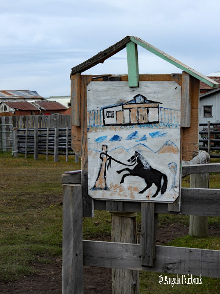               That done, we returned to our buses and entered the pier, where we found two more ships at berth that were much, much larger than ours (which dwarfed them and whose passengers for this voyage, I was told, number 137 with 105 crew members): Viking Jupiter, capacity 1,000, on its South America and Chilean Fjords itinerary, and Holland America's Oosterdam, capacity 2,000, both of which we will likely meet again in the Falklands. We were asked to scan our luggage once again by the Chilean navy, after which we passed through a room filled with handicraft vendors, and then a final time on boarding our ship. On checking into the ship, I found that I had received a stateroom/cabin upgrade, which meant more space, and, thankfully, an actual desk to work at. This put me port side forward, while the last time I had been on this ship, eight or so months ago, my cabin had been on the same deck but starboard aft. I then received my gum boots for landings and the patch of the animal group (Fin Whale) to which I had been assigned for zodiac travel. After unpacking my suitcase, finding places in my room for everything, and attending the mandatory safety briefing, I went for dinner and then straight to bed.
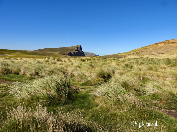
Sunday, March 1, 2026: At Sea, South Atlantic Ocean  Today I woke up late and consequently missed breakfast, although I had slept well for once. I attended two lectures on the Falklands, one on its geography, history, economy, etc. and the other about its bird life. Here are some of the facts I retained. The Falkland Islands consist of two main islands called West Falkland and East Falkland, although there are actually 778 islands in all. The first sighting of this archipelago was in 1592 by John Davis. In 1594, Sir Richard Dawkins mapped the northern coastline. The first recorded landing was in 1690 by John Strong and it was named the Falklands after one of the investors of Strong's expedition. The first settlement (French) was in 1764, while the British created a settlement in 1765. In 1767, the French sold their land to the Spanish. Charles Darwin visited the Falklands in 1833 and 1834 and pronounced it desolate. In 1845, Stanley became the capital and the Falklands were known at that time as a ship repair base. The whale oil trade ended both in the Falklands and in South Georgia in 1965. The last mines were cleared in October 2020. Stanley is the only real town in the Falklands today and contains a population of 3.5 thousand consisting of 49 nationalities. There are schools, churches, restaurants, shops, and a golf course. Its economy is based on fishing (squid represents a 45-million-pound economy and is the national dish), sheep farming (wool products), and tourism. There is also a small gin distillery. A wind farm with 6 turbines provides 40% of the town's electricity needs, but it also has solar panels and diesel generators. Its roads are paved only in Stanley, and the favourite vehicle is the Land Rover. And finally, the Falklands have their own currency, the local equivalent of British pounds, but it cannot be used in the UK. Their coins, which are among the smallest in the world, feature images of local wildlife.
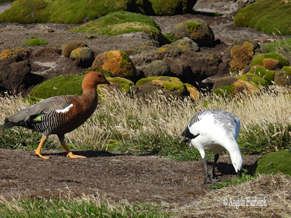
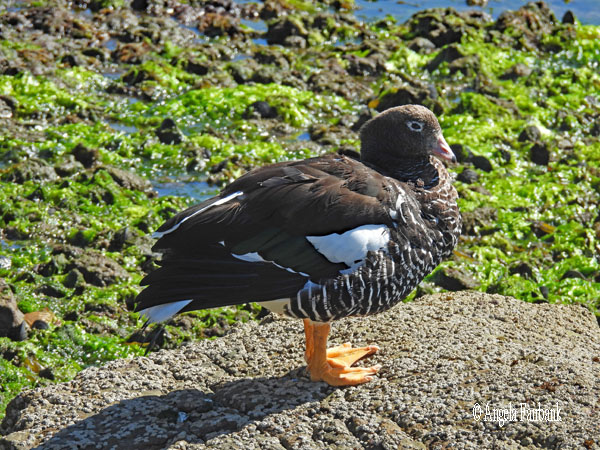
As for birdlife, one of the two ornithologists on board told us that there are 213 species here on the Falkland Islands, 62 of which are resident and 2 are endemic. There are also 15 subspecies. They are distributed quite evenly as 35% seabirds, 35% land birds, and 30% water birds. Five species of penguins make their home here: Gentoo, Magellanic, King, Rockhopper, and Macaroni. The Falklands also contain 70% of the world's population of Black-browed Albatross. We should be able to see their fluffy grey young as they are currently moulting. They tend to breed in the same area as penguins. Two predator birds are Southern Giant Petrels and Brown Skuas with their white wing flashes. We should also see Kelp, Dolphin, and Brown-hooded gulls as well as Imperial (blue eyes) and Rock (red around the eyes) Cormorants. As water birds, we should see the endemic Steamer Ducks, which are flightless, although there is also a Flying Steamer Duck, whose wings are more developed than their cousins. Among the geese here we should see Upland, Kelp, and Ruddy Headed. Other birds in this category here are Black-Crowned Heron, Two-Banded Plover, Rufous-Chested Dotterel, White-Rumped Sandpiper and both Blackish and Magellanic Oyster Catchers. Among the songbirds we may see are Cobb's Wren, Austral Thrush, Tussak Bird, Dark-faced Ground-Tyrant, White-Bridled Finch, Black-Chinned Siskin, and the Long-Tailed Meadowlark. Possible birds of prey are the Striated Caracara, Southern Caracara, Variable Hawk, Peregrine Falcon, Short-eared Owl, and Turkey Vulture. I wonder how many of these I will be able to photograph and tick off my list! I attended the Captain's cocktail party in the late afternoon before dinner, at which we were introduced to the officers and expedition team, and an evening meeting after dinner to learn about the two landings we would attempt to make tomorrow on outer Falkland Islands called New Island and Carcass Island. I spent the remainder of my hours today (apart from eating lunch and dinner) writing down here what I had accomplished over the last few days. 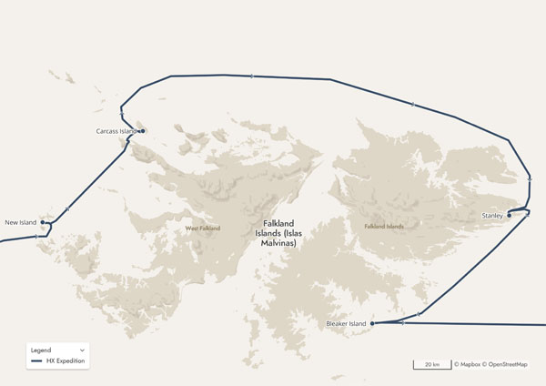 Monday, March 2, 2026: New Island (51.7163° S, 61.2928°) and Carcass Island (51.2804° S, 60.5631° W), West Falkland Islands
Wikipedia provides a bit more information than what our lecturer did yesterday: The Falkland Islands, or in Spanish Las Islas Malvinas, commonly referred to as The Falklands, is an archipelago in the South Atlantic Ocean on the Patagonian Shelf. The principal islands are about 300 mi (500 km) east of South America's southern Patagonian coast and 752 mi (1,210 km) from Cape Dubouzet at the northern tip of the Antarctic Peninsula, at a latitude of about 52°S. The archipelago, with an area of 4,700 sq mi (12,000 km2), comprises East Falkland, West Falkland, and 776 smaller islands. As a British Overseas Territory, the Falklands have internal self-governance, while the United Kingdom takes responsibility for their defence and foreign affairs. The capital and largest settlement is Stanley on East Falkland.      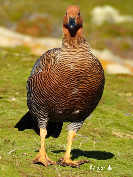 The islands are believed to have been uninhabited prior to European discovery in the 17th century. Controversy exists over the Falklands' discovery and subsequent colonization by Europeans. At various times, the islands have had French, British, Spanish, and Argentine settlements. Britain reasserted its rule in 1833, but Argentina maintains its claim to the islands. In April 1982, Argentine military forces invaded the islands. British administration was restored two months later at the end of the Falklands War. In a 2013 sovereignty referendum, almost all of the votes cast were in favour of remaining a UK overseas territory. The territory's sovereignty status is part of an ongoing dispute between Argentina and the UK.
   The population [3,465 inhabitants in 2026 compared to half a million sheep] consists of around 40% native-born Falkland Islanders, with the rest of the population being immigrants, primarily from the United Kingdom, the South Atlantic island of Saint Helena, Chile, and the Philippines. Around 30% of the population are temporary residents on short-term work visas or working at the RAF Mount Pleasant military base. English is the official and predominant language. Under the British Nationality (Falkland Islands) Act 1983, Falkland Islanders are British citizens.
      The islands lie [approximately 1,300 km from South Georgia] at the boundary of the subantarctic oceanic and tundra climate zones, and both major islands have mountain ranges reaching 2,300 ft (700 m). They are home to large bird populations, although many no longer breed on the main islands owing to predation by introduced species. Major economic activities include fishing, tourism, and sheep farming, with an emphasis on high-quality wool exports. Oil exploration, licenced by the Falkland Islands Government, remains controversial as a result of maritime disputes with Argentina.
   Our first landing this morning, at about 8:30 a.m. was, as mentioned yesterday, on New Island. According to a plaque inside its museum, New Island is “one of the finest and most unique wildlife reserves in the Falkland Islands [and] is protected by the New Island South Conservation Trust ... Much of the island's earlier history was one of depredation: its seal and bird colonies were plundered by early exploiters, the island was a base for whalers, and its vegetation suffered as a result of burning and grazing by sheep and cattle ... The most westerly of the island group, ... New Island lies in the SW corner of the Falkland Islands archipelago 237 km from the capital, Stanley, and 354 km from the nearest point on the South American continent. The island has 84 km of coastline embracing approximately 4,000 ha ... At its highest point, ...cliffs rise 180m from the ocean.”
      The above-mentioned museum was located inside the 2006-restored Barnard Building, “named after Captain Charles H. Barnard, an American from Nantucket, who whilst engaged in a sealing venture around the Falklands in 1813, was marooned along with four of his men on New Island. These events occurred in the context of the war between America and England in 1812. After rescuing survivors of the wreck of the British ship Isabella, which had gone aground on Speedwell Island, Barnard and his men were left on New Island by the very men they had saved. With his own vessel, the Nanina, stolen, Barnard and his companions were left with only a few personal items, his dog, and an open boat. For two years, they survived on or about the island until they were eventually rescued. Barnard describes his exploits in a book he published in 1829...called Marooned.”
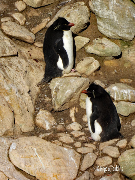
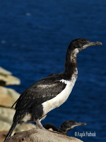
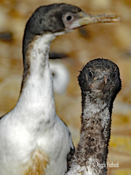
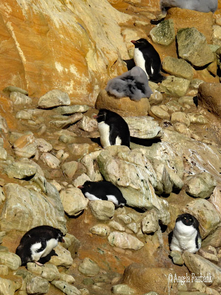
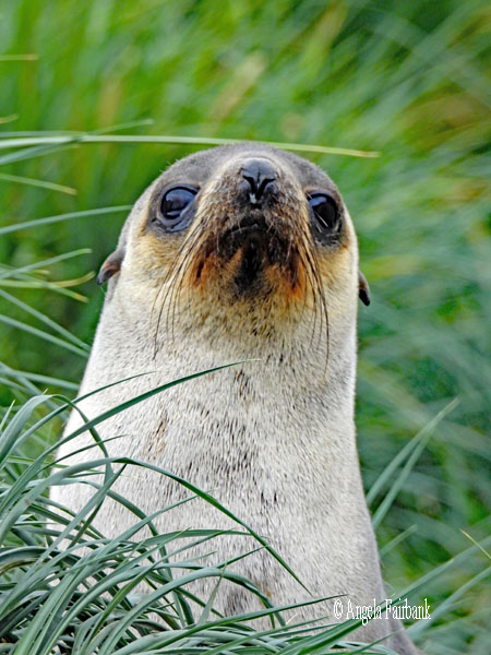
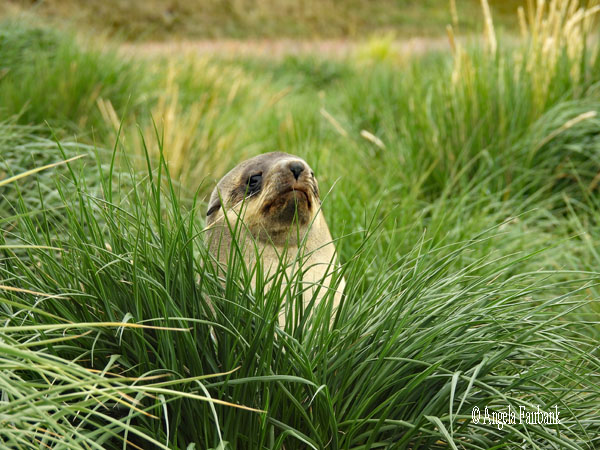
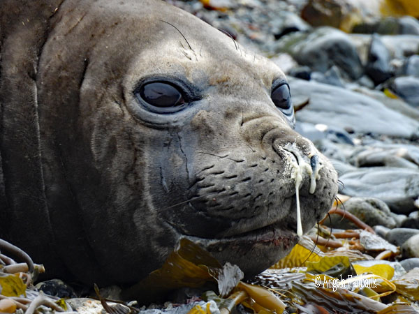
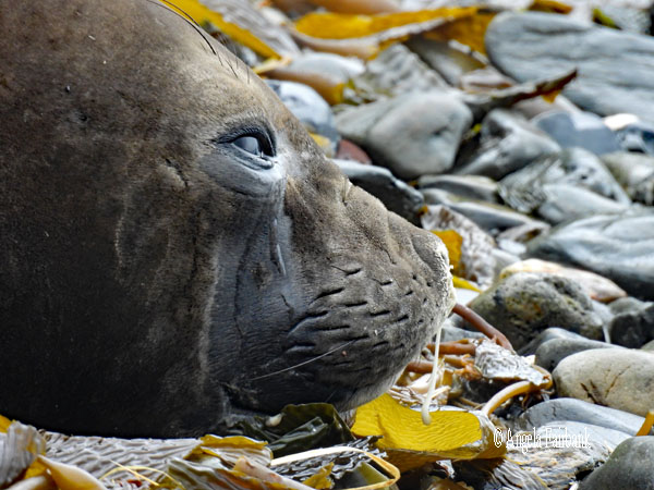
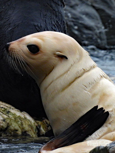
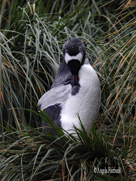
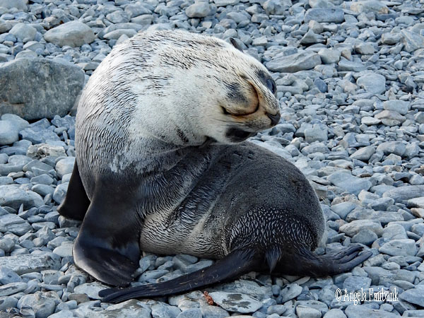
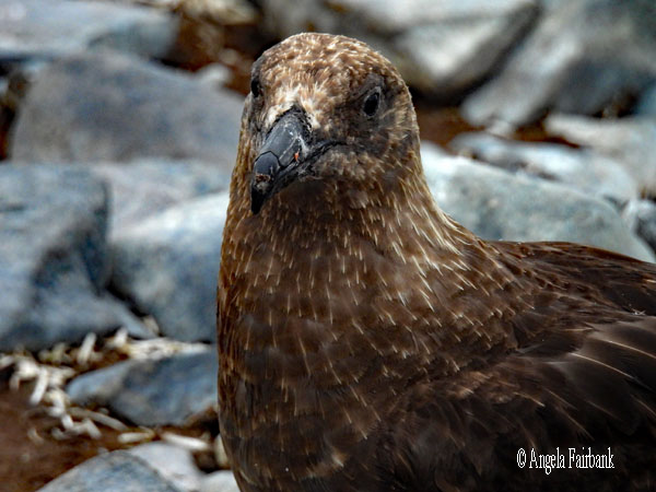
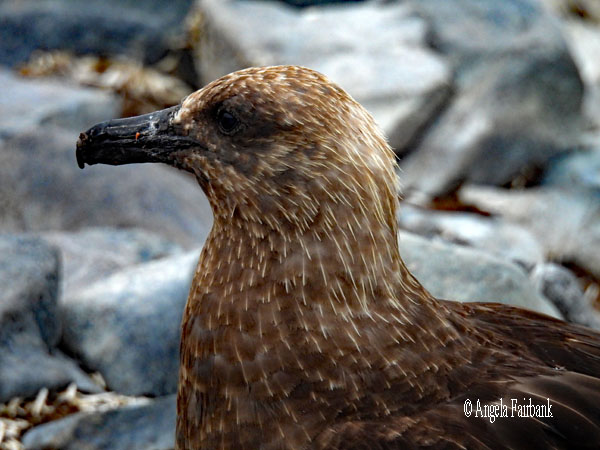
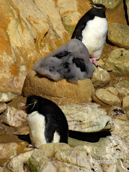      After landing on the grey-sand beach of Settlement Harbour (formerly Coffin's Harbour) in a cove of turquoise water marked by a rotting ship hull (belonging to the Protector, a small, 471-tonne sand dredger, brought to the island for a sealing venture in the late 1930s and which ultimately ran onto the beach), we first saw pairs of Uplands Geese (also known as Magellan Geese Chloephaga picta) and Kelp Geese (Chloephaga hybrida) on the shore and later dotted about among the Tussac Grass (Poa flabellata). This vegetation, which covers the island (there are no trees), grows up to 3 metres high and is used by 46 species of birds to nest, including Black-Brow Albatross (Thalassarche melanophris). Grass Wrens (Cistothorus platensis), which I did not see, also feed on this grass. After I had photographed this Dark-faced Ground-Tyrant (Muscisaxicola maclovianus), we were shown an earthen path we could take through the grasslands to cliffs, on which there were colonies of Imperial Cormorants aka Blue-eyed Shags (Leucocarbo atriceps) and the smaller Magellanic Cormorants (Leucocarbo magellanicus) aka Rock Shags, the aforementioned Black-Brow Albatrosses, and Southern Rockhopper Penguins (Eudyptes chrysocome), visited by Brown Skuas (Stercorarius antarcticus) and Striated Caracaras (Daptrius australis), known locally as 'Johnny Rooks.'
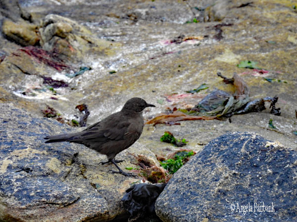
   It was so windy up on the cliff, it was difficult to stand upright, let alone photograph, but I tried my best. My favourites were the Southern Rockhopper Penguins, the smallest of the four main species of penguin found in the Falkland Islands, according to information found at the museum here, although they were not near enough for my liking. Luckily for distance photography, they weren't moving much as they were moulting (for which, we were told, they needed to be fasting). I asked whether we would see any more of these particular penguins on other islands in the Falklands, but the answer seemed to be no, which was disappointing. When I asked Google, I read “Southern Rockhopper penguins are best seen in the wild on the Falkland Islands, which host massive, accessible colonies, as well as on remote sub-Antarctic islands, South Georgia, and in southern Chile/Argentina.” There was also an LBJ, called a Tussac-Bird (Cinclodes antarcticus) scavenging around, but it was very difficult to photograph as it kept on moving with the wind blowing hard. I also photographed a Dolphin Gull (Larus scoresbii) in among the Cormorants here.
   On my way back down to the shore, I noticed a path off to the left and climbed up to a grave, marked by this seal (or walrus) headstone. I believe it is fairly recent and belongs to a conservationist who asked to be buried here. Coming back to the museum and regretting the fact that I had not thought to bring any Euros or credit cards with me for the shop inside, I also saw some flightless Falkland Steamer Ducks (Tachyeres brachypterus) swimming in the shallow water by the sandy beach. So not bad for the first day. I think I managed to tick 12 species off that list compiled at yesterday's lecture.
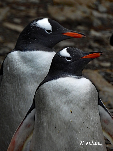
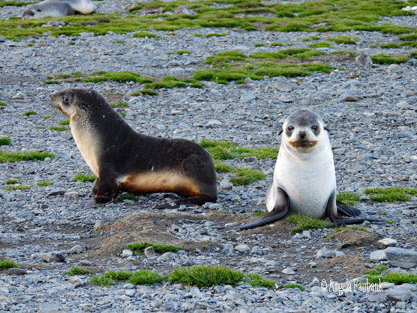
      After lunch, I worked at my desk for a while. The sea was a bit choppy but we managed to head northward to another small island in the eastern half of the Falklands, called Carcass Island. I was expecting it to be full of carcasses but it was quite pleasant and full of birds, more geese, more caracaras, more steamer ducks but also two Magellanic Penguins (Troglodytes cobbi.), which I'd first seen in Argentina on my boat ride through the Beagle Channel when I had stayed some days in Ushuaia, and some smaller birds. Apparently, the island, with an area of 19 square kilometers and named after the Royal Navy ship HMS Carcass, which surveyed the area in 1766, had been operated as a sheep farm for over a century, and is privately owned (currently by the McGill family). It is also known for its conservation efforts, being free of rats and cats. The current owner, who invited us all into her home for tea and a huge variety of cakes and cookies, into which we hardly even made a dent, was born there and has lived there all her life with only occasional visits to the British Isles. Our group was the first called to the zodiacs and so after landing on shore, I was one of the first to wander around through pastures and up to an area where we were told there were burrows where Magellanic Penguins had their nests. As it was the end of the season, we were not sure how many were in these burrows as we were not allowed to get too close, but I was extremely lucky because one of them poked its head up and I got a few shots. By the time a couple more passengers had caught me up, the penguin had popped down into the burrow once again.
 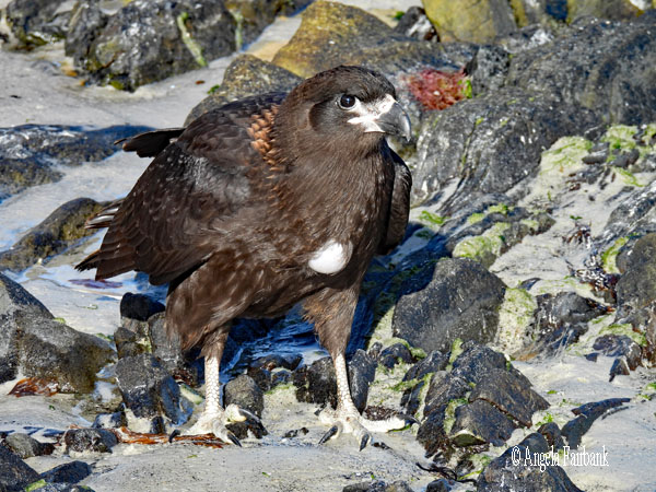        On my way back to the house, I photographed this wonderfully colourful male Long-Tailed Meadowlark (Leistes loyca) and this Austral Thrush (Turdus falcklandii), among more that I later saw on the evergreens around the house. Tussac Birds were scavenging among the rocks on the beach. After then grabbing a cup of tea and a biscuit, I headed out to the other side of the island along the path, where I got a quick not very good snap of a yellow-coloured Black-Chinned Siskin (Spinus barbatus), and joined a group with the ornithologist, who were photographing a Cobb's Wren (Troglodytes cobbi) in among piles of dead wood. Up this path, there were several juvenile Caracaras with their crocks distended in the guise of a large round white ball where their breastbone would be, one of which we observed for a while as it took a bath in the dirt in the middle of the path. AI explains that this “distended crop protrusion is a common, harmless phenomenon in raptors, especially young ones, caused by a full stomach and specific anatomical features...The crop (or ingluvies) is a muscular pouch in a bird's neck used to store, soften, and regulate the flow of food to the stomach. Young, growing raptors like the Striated Caracara often gorge on food, causing the crop to bulge out dramatically...Similar to other raptors, the skin over the crop of a caracara is not covered in feathers. When the crop is extremely full, it protrudes through the surrounding plumage, making it highly visible. The crop often appears to have a pale or white color, particularly in juveniles, as the distended skin stretches and becomes visible through the surrounding feathers, resembling a ping pong ball or white lump, particularly after feeding on seabird carcasses or chicks.”
   The sky was clouded over during this visit, but when it came time to leave, the height of the waves had increased, and the zodiacs were unable to come and pick us up as regularly as planned. This meant that by the time we were ready to leave, there was a long line of us in our blue anoraks ready to board. As we waited, we observed a second Magellanic Penguin arrive onto shore from the sea and stroll uphill toward the burrows. He saw us, stopped and looked at us, but feeling unthreatened, continued upon his way. Thankfully, the zodiacs were eventually sent ashore again, but it did mean that we had a rather choppy, wet ride back (as incidentally we had had on the way out) as the waves splashed over the bow. Then when our zodiac arrived at the ship's landing deck, only two passengers got out before there was a huge swell and our driver had to move us away. We then circulated in the area in the zodiac as we waited for the waves to die down somewhat and let other zodiacs deposit passengers before we made another attempt. Finally, we were all back on board. I changed out of my wet things, laid them on the ground in my bathroom, turned on the floor heating, and went off to dinner, where I was seated beside the only other Canadian on the ship, a woman slightly younger than me from a small town in Ontario. I remembered then that I had been the only Canadian onboard the MS Fram during my trip around the Svalbard archipelago back in June/July.
      Tuesday, March 3, 2026: Stanley, East Falkland Island (51.6928° S, 57.8620° W)
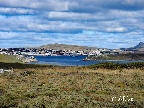
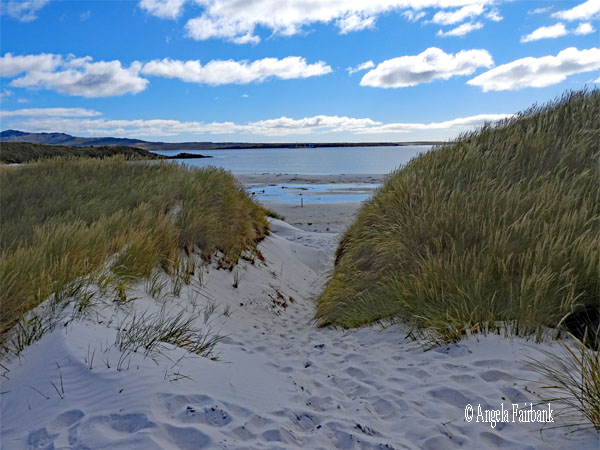
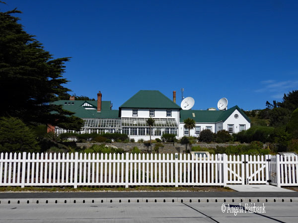
We arrived in the capital of the Falkland Islands around 7:00 a.m. just as I woke up. Grabbing breakfast and changing into my boots for environmental security purposes but otherwise my own outdoor clothing and not what had been issued to us by HX, I was on the bus for the complementary tour to Gypsy Cove, but found it rather underwhelming, not only because we were not the only group there...there were easily a couple thousand passengers off the Holland America ship and they were certainly not environmentally conscious, stepping off the path, leaving a cigarette butt and other paper garbage on the path, and talking in loud voices, but also because since it was the end of the season there wasn't much wildlife to see here, although I have no idea what it is like during the actual season. We did see about four Magellanic penguins either lying in burrows or standing and hiding behind tall grass as they moulted, but otherwise it was the usual Kelp and Uplands Geese, and Steamer Ducks way below us on the beach, as pristine and white as its photogenic sand was, as we strolled on a path around the cliffs. There was also some paraphernalia from the Falklands War (one of the plaques warned us that this was a former 1982 conflict minefield site), as well as a large, mounted naval gun from World War II.  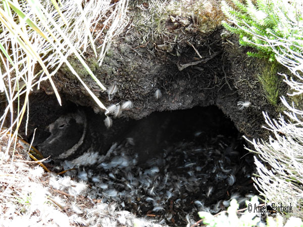     I walked along the path that ran parallel to the beach and ended up in a sandy part dotted with Tussac Grass and then found my way to the road so I could return to the car park by foot. They had toilets there but nowhere to wash hands. I pointed out to the two young park attendants that there was no more hand sanitizer in the dispenser, but they basically just shrugged their shoulders and went to greet the next busload of tourists. Our bus loaded up again and we were driven back to the ship to sanitize our boots and then I went back out and took the shuttle bus into the town of Stanley, which reminded me somewhat of Lunenburg in Nova Scotia. It was a warm, sunny day by then, so I was walking around town in a t-shirt. After picking up a free map from the tourist office and buying a lovely sweatshirt as well as a fridge magnet and a tiny penguin made of wool, I explored the town. I had only Euros in cash with me and this befuddled the saleswoman who said she only accepted British pounds and credit cards. Luckily, she had a sheet that gave an approximation of the equivalent exchange rates, and no doubt because she wanted to make a sale, she reluctantly accepted my Euros and gave me back some change in USD.
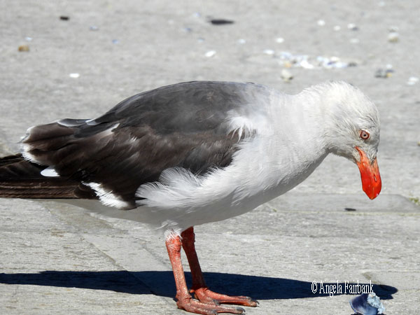
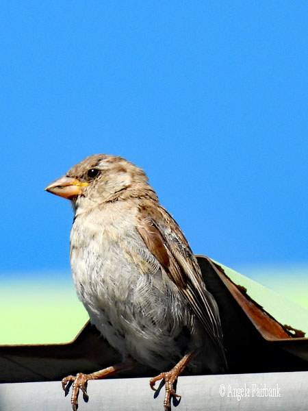
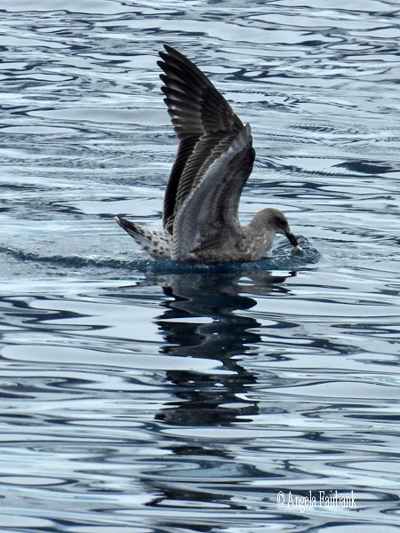
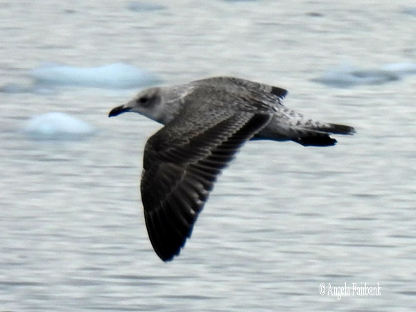
         I then followed the map I had picked up and walked up a few blocks and over quite a few more to get some photos of this and that, as you will see here. The red-beaked gull on the pier is a dolphin gull (Leucophaeus scoresbii), while the ones with yellow beaks are kelp gulls (Larus dominicanus.). The small birds I kept on seeing in gardens and around houses were disappointingly House Sparrows (Passer domesticus), a species that had been introduced to the Falklands at some stage. I also visited the Historic Dockyard Museum, which was overwhelmingly chock-a-block full of stuff. I tried to buy a t-shirt with the five penguins found in the Falklands (Gentoo, Magellanic, Southern Rockhopper, King, and Macaroni) on it, but regretfully the saleswomen there outright refused my Euros. I availed myself of the toilets here, which were well stocked, clean, flushed, and had sinks and soap with which to wash our hands afterwards. I then made my way back to the shuttle bus and returned to the ship 2:00ish to eat a banana from breakfast as I had missed lunch and then worked on this travelogue.
         Around dinner time, after we had passed through the strait called 'the Narrows' to exit Stanley, there were a couple of Southern Right Whales (Eubalaena australis) in the water quite close to our ship, who showed us their flukes at the end of their visit before diving down to the depths. At our after-dinner meeting, we learned that tomorrow we would attempt to visit Bleaker Island, southwest of Stanley, and our last stop in the Falklands, although the waves would likely be choppy and the weather, rainy.
         Wednesday, March 4, 2026: Bleaker Island, Falkland Islands
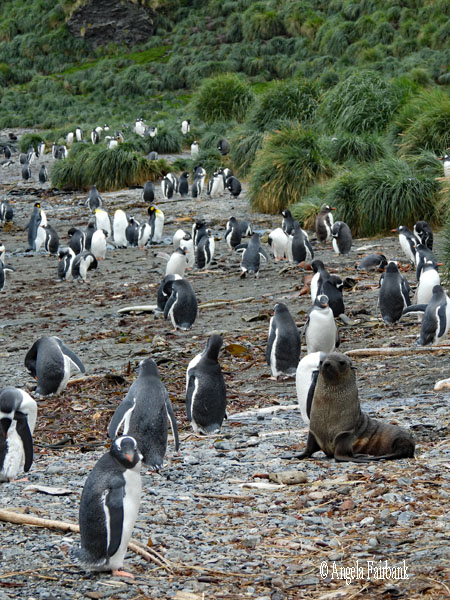
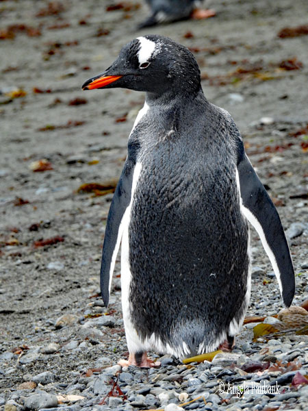
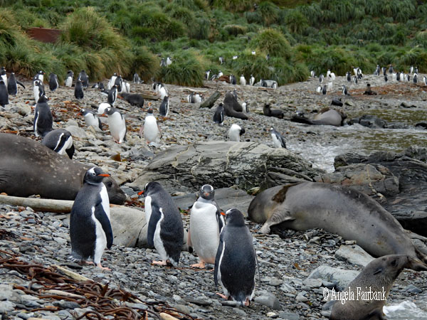
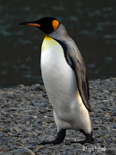
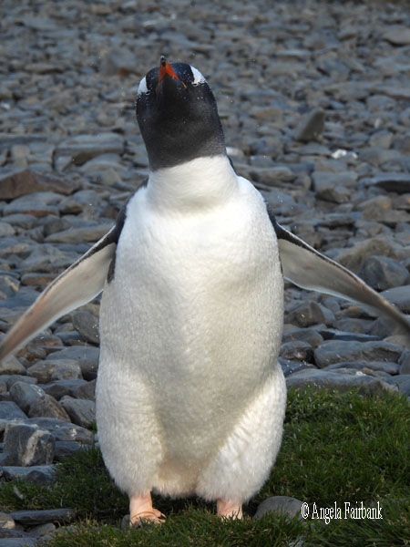
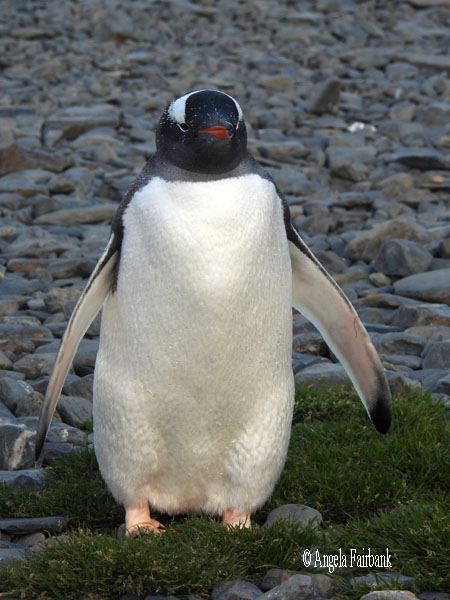
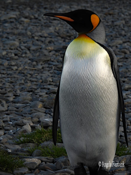
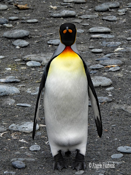
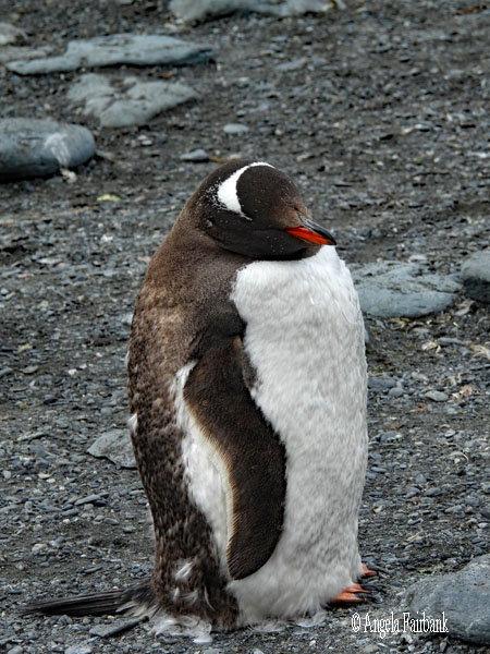
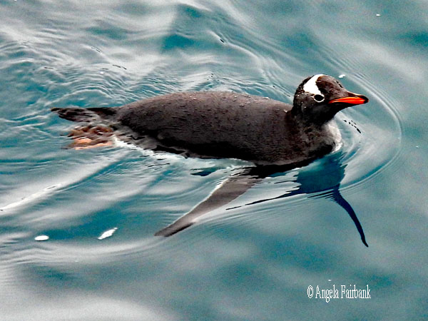
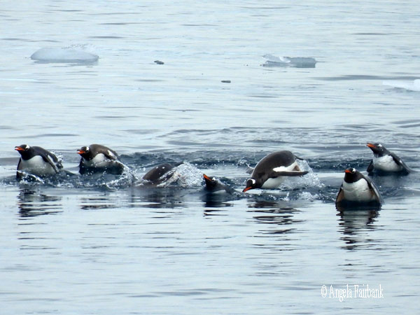
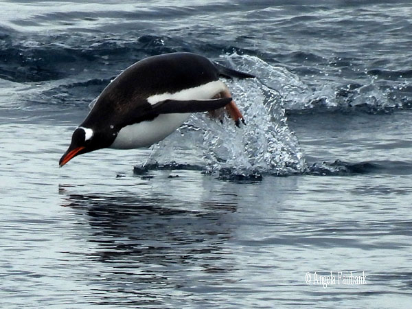
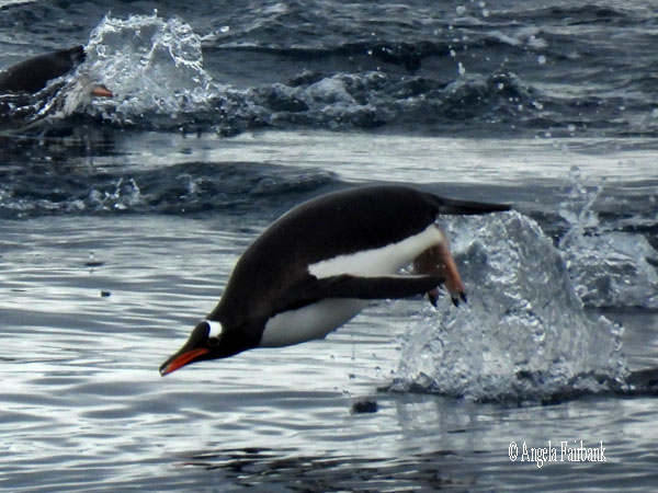
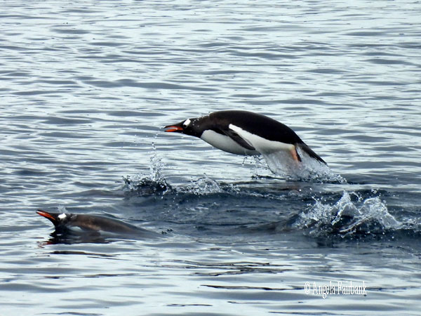
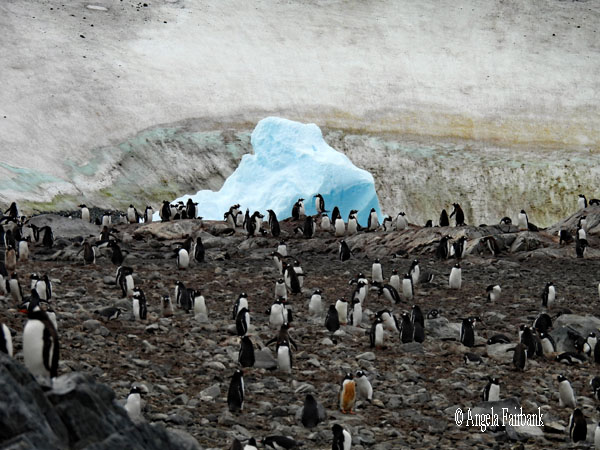
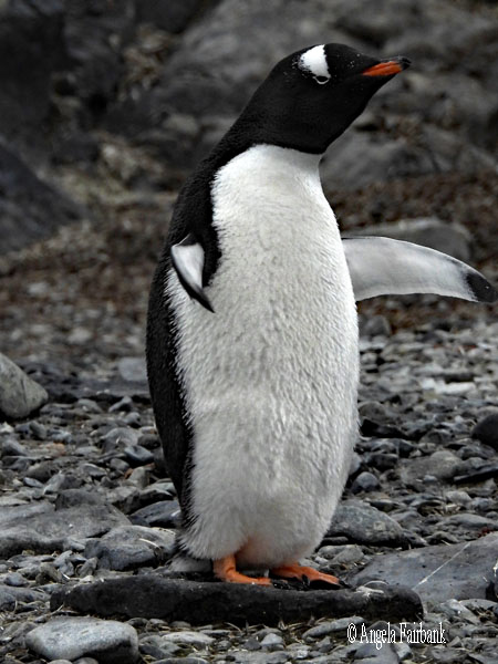
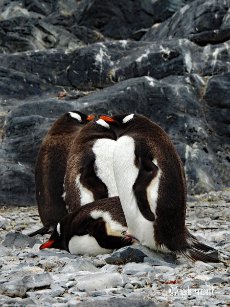
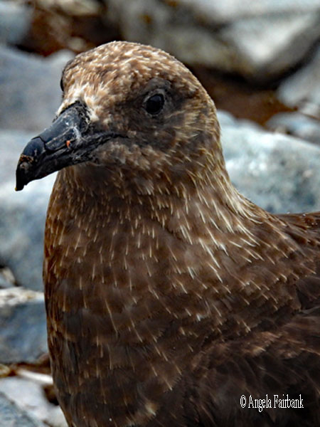
Due to the weather, which was forecast to become even worse during today and the following days, we headed out to Bleaker Island soon after I had grabbed a small breakfast from the dining room (8:30ish). Our group was the last of six to be driven out to the island in zodiacs. Although I was praying that the skies would clear, it rained the entire time. Our ride onto the beach was short and we were greeted by a few dozen or so adult Gentoo penguins (Pygoscelis papua), which of course I'd seen before in Antarctica in November 2024, hanging out on the sand and getting ready no doubt to swim out and gather food for their young. The land was flat, so we grabbed some walking poles and traversed the wet beach to reach grassland, which was full of Magellanic penguin burrows, and standing Gentoo penguins, the young still in their downy black feathers in the midst of moulting. I did catch sight of a couple of penguin carcasses, no doubt caused by some of the brown skuas (Stercorarius antarcticus) hanging about the place. There were about three waddles (or colonies) or these penguins bunched together and standing more or less unmoving in the rain. I was reluctant to pull out my camera knowing it would get wet, but thought if I didn't, I wouldn't remember this place, nor could I show you what I saw. I was therefore extremely conservative with my shots and due to the rain didn't bother walking toward a third grouping, although I learned later that, had I done so, I might have caught sight of a sole King Penguin (Aptenodytes patagonicus) standing head and shoulders above the Gentoos because the average height of a King Penguin is 95 cm, while that of a Gentoo is 71 cm. I was promised by the ship's ornithologist that I would see many more King Penguins in South Georgia (and perhaps even some Emperors (Aptenodytes forsteri, which are even taller at 120 cm, although not so striking as the Kings with their bright orange patches.) I have my fingers crossed.   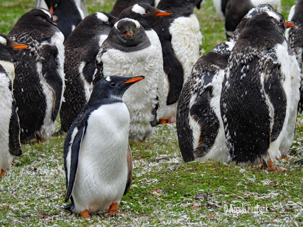 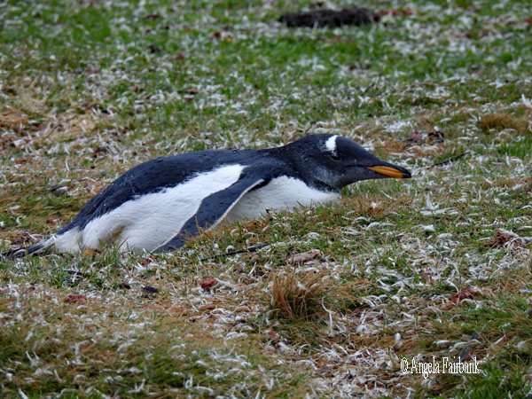 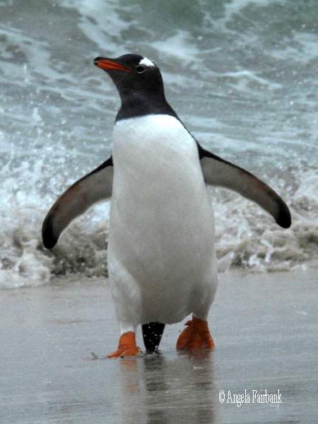  After returning to the ship, we left our anchorage earlier than planned, due to the fact that nobody wanted to hang out in the rain and become even wetter, and resumed our crossing of the Southern Atlantic towards South Georgia. I worked on my photos and then on this travelogue and finally had a chance to work on a chapter of my book translation.
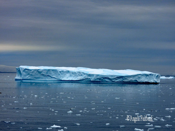
Thursday, March 5, 2026: At Sea, South Atlantic Ocean It was quite a choppy night from strong winds and high waves, so I stayed in bed a bit longer than usual and missed breakfast. I then did some laundry and caught up on a couple of lectures I had missed, which had been recorded and were available for viewing on the television in my cabin. Before lunch, I went to lectures that introduced us to South Georgia and its birdlife, some of the factoids of which I will attempt to reproduce here. South Georgia is a remote archipelago of 100,000 hectares containing glaciers and mountains. It was first discovered in 1675, and the first landing was made in the HMS Resolution by Captain James Cook, who claimed it for Great Britain. He named the cape 'Cape Disappointment' because he first thought he'd arrived in Antarctica. South Georgia used to be a secretive site for sealing and whaling. The fur and elephant seals caught for food and fur eventually became extinct, so traders tuned to whaling in 1904 when the first permanent whaling station was built in Grytviken (its capital) by the Norwegian, Carl Anton Larsen. In these whaling ships, they inevitably brought mice and rats, which then inhabited the islands. The whalers also hunted the penguins for meat and fuel to process the whale oil. South Georgia became the British Overseas Territory of South Georgia and the South Sandwich Islands in 1985, and tourism started here due to wildlife documentaries. In 2015, the islands of the archipelago were declared reindeer free but getting rid of the rats and mice proved more difficult as these rodents liked to nest in the Tussac Grass. Eradication of these rodents was begun in 2011 through raising funds among tourists and in 2018 the archipelago was finally declared rodent free. Regarding its birds, the South Georgia Pipit (Anthus antarcticus) is endemic and the southernmost songbird in the world. The other endemic bird is the South Georgia Pintail Duck (Anas georgica georgica). There are also three types of albatross here: the Grey-Headed Albatross (Thalassarche chrysostoma), the Light-Mantled Albatross (Phoebetria palpebrata), which is sooty-coloured, and the Wandering or Snowy Albatross (Diomedea exulans), which has the largest wingspan (12 feet long) in the world and weighs up to 30 lbs. Giant Petrels (Southern (Macronectes giganteus) and Northern (Macronectes halli)) can also be found here, as can Gentoo and Macaroni Penguins (Eudyptes chrysolophus), which with their golden crests are the most numerous penguin species in the world at about 1 million breeding pairs (down from 5 million). We might also see Antarctic Prions (Pachyptila desolata), Wilson's Storm Petrel (Oceanites oceanicus), and the South Georgia Diving Petrel (Pelecanoides georgicus). I worked some more on my book translation for the rest of the day as the sea continued to be choppy and it was not possible to go out on deck to photograph flying birds. Friday, March 6, 2026: At Sea, North Scotia Sea Today at sea we began seeing our first large icebergs. We also had a lecture about what to expect in South Georgia, including a short film by Sir David Attenburgh, although to my disgust, the film did show him lying on the ground, and other people sitting on the ground to photograph, which today is totally forbidden, added to the fact that there is now avian flu present so tourists allowed on the islands in this area need to be extra specially vigilant not to touch anything with anything, with the exception of their pre-and post-sterilized HX-provided muck boots. Later on this morning, we watched a presentation on the extra activities we could sign up for in South Georgia and Antarctica. I figured I would try for the third time to go kayaking here (my last two times--once in Antarctica and once in Svalbard--had been cancelled due to rough weather). As of this year, we were told, they have introduced one-person, inflatable kayaks, making it a slightly less expensive activity, and providing us kayakers with more autonomy and what looks like a safer entry and exit, using platforms suspended between two zodiacs in the water. I have signed up for that. I have also not yet attempted to sleep in a tent in the Antarctic, so I figured since this would be my last time in this part of the world, it was now or never. Mind you, I was reminded of my last time sleeping in a tent, which was in South Sudan with the Mundari, and how my fellow travel companion and I opted out of spending a second night in the tent, but this was mainly due, if I remember, to stinking of cow dung smoke, and the attraction of the shower back at the hotel, which we opted for. One Dutch woman, who is staying in the cabin opposite mine and whom I met in the line up at the Hyatt Hotel in Santiago our first day, suggested sharing a tent, because the other option was to sleep singly in bivouacs, which don't have as much room, and might be rather claustrophobic. They showed us what the improvised toilets on land in the snow would be like too and strangely, I was not put off. It's certainly not cheap to do either activity, but at least it will be something to bring up in conversations, and perhaps provide for interesting photos, as long as my cameras do not run out of battery power. This afternoon we had two cleaning sessions: first, we had to vacuum all dirt, sand etc. out of our over clothes we had worn or bags we had brought onto landing sights in Falklands; secondly, we had to wash our boots and make sure there were no small pebbles trapped in any crevices. All in an effort not to bring into South Georgia any foreign plants, seeds, or infected bird faeces we had picked up inadvertently in the Falklands. We shall be performing this exercise once again between leaving South Georgia and entering Antarctica.  Saturday, March 7, 2026: Sandebukten (54.3116° S, 36.3600° W) and Godthul, South Georgia (54.2800° S, 36.2833° W)
According to Wikipedia, South Georgia and the South Sandwich Islands (SGSSI) is a British Overseas Territory in the southern Atlantic Ocean. It is a remote and inhospitable group of islands, consisting of South Georgia and a chain of smaller islands known as the South Sandwich Islands. South Georgia is 165 kilometres (103 mi) long and 35 kilometres (22 mi) wide and is by far the largest island in the territory. The South Sandwich Islands lie about 700 kilometres (430 mi) southeast of South Georgia. The territory's total land area is 3,903 km2 (1,507 sq mi). The Falkland Islands are about 1,300 kilometres (810 mi) west from its nearest point. 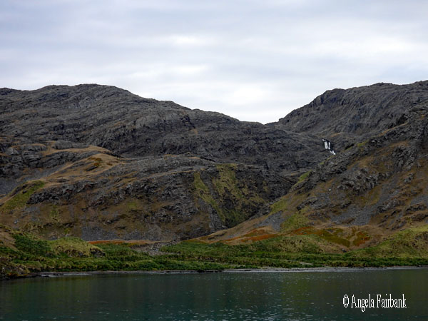    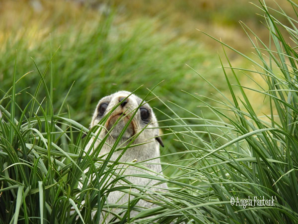 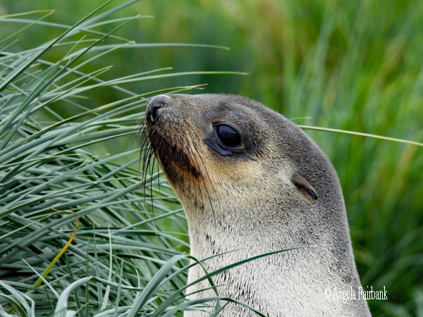 The South Sandwich Islands are uninhabited, and a very small non-permanent population resides on South Georgia. There are no scheduled passenger flights or ferries to or from the territory, although visits by cruise liners to South Georgia are increasingly popular, with several thousand visitors each summer.
      The United Kingdom claimed sovereignty over South Georgia in 1775 and the South Sandwich Islands in 1908. The territory of South Georgia and the South Sandwich Islands was formed in 1985; previously, it had been governed as part of the Falkland Islands Dependencies. Argentina claimed South Georgia in 1927 and claimed the South Sandwich Islands in 1938.
      Argentina maintained a naval station, Corbeta Uruguay, on Thule Island in the South Sandwich Islands from 1976 until 1982 when it was closed by the Royal Navy. The Argentine claim over South Georgia contributed to the 1982 Falklands War, during which Argentine forces briefly occupied the island. Argentina continues to claim sovereignty over South Georgia and the South Sandwich Islands as part of their Province called Tierra del Fuego, Antártida e Islas del Atlántico Sur.
      The sole official language of the territory is English, which is widely spoken amongst residents currently and used for nearly all administrative functions in the territory.
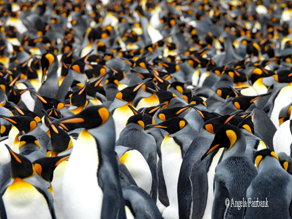
         We arrived this morning in much calmer waters, finally, in which small icebergs were floating, and saw land which was Tussac-Grass green and rocky on the lower elevations and snowy and misty on the higher, mountainous heights. Anchoring in a harbour by Sandebukten (which means sandy place in Norwegian), through my long lens, I was able to see my first King Penguins, in addition to a few Gentoos, on the beach, plus seals (Elephant and Fur) in various age groups, whose grunts we could hear, as well as Antarctic Terns fishing and a Giant Petrel swimming in the sea. Divided into our groups, we were not able to go ashore until the second lot of zodiacs were ready, so in the meantime, I made sure my cameras and spare batteries were fully charged as it is about minus 2 degrees Celsius at the moment. The sky is overcast but at least it's not raining.
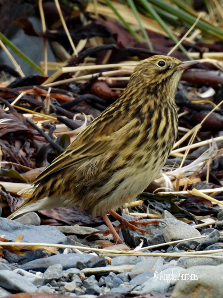
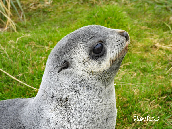
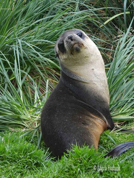
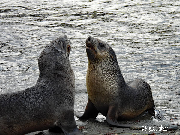
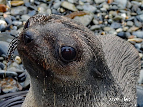
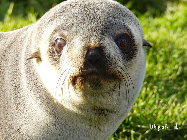
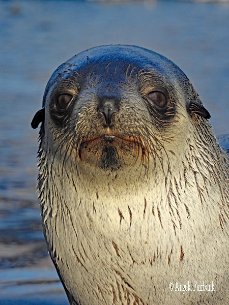
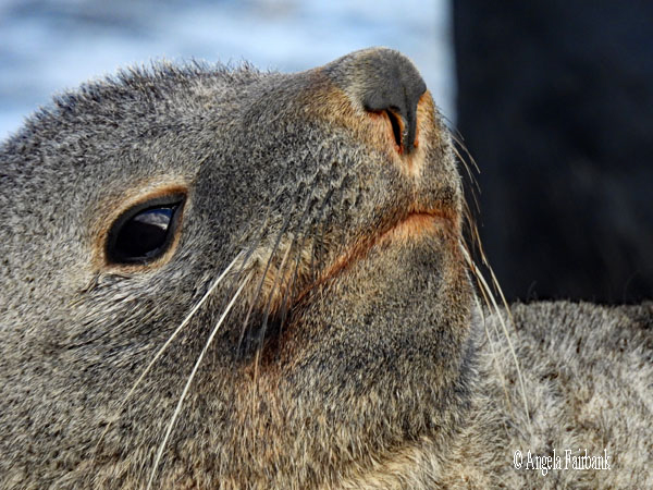
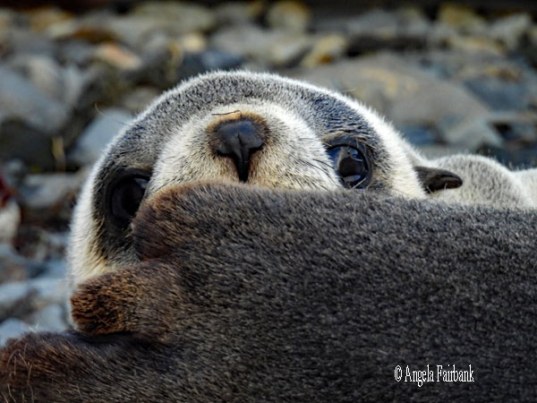
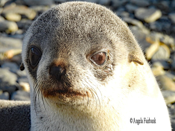
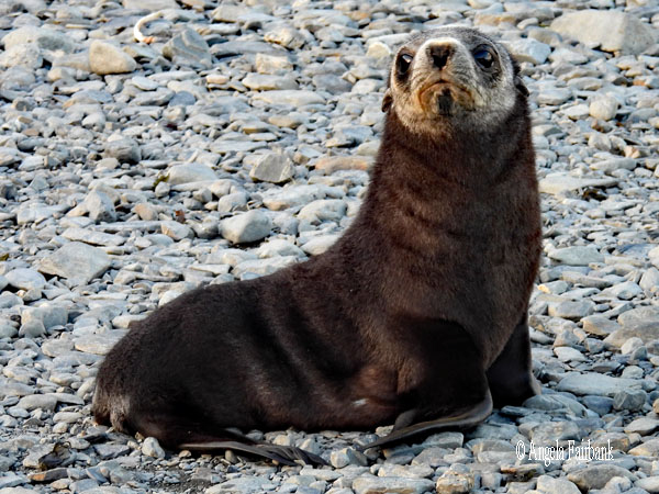
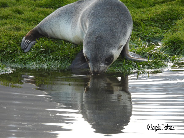
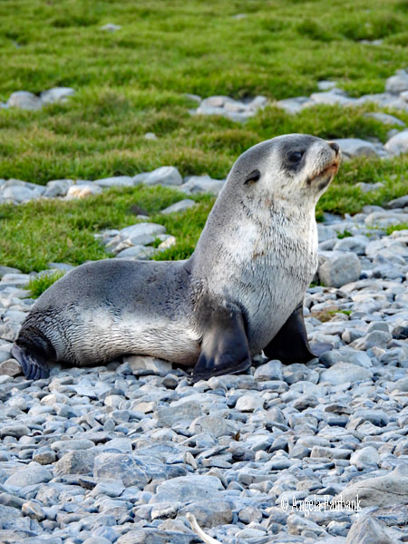
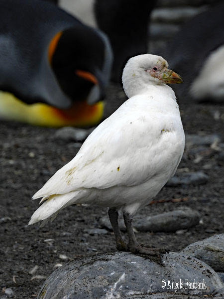
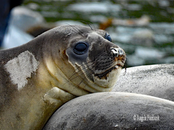
   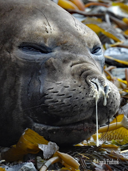 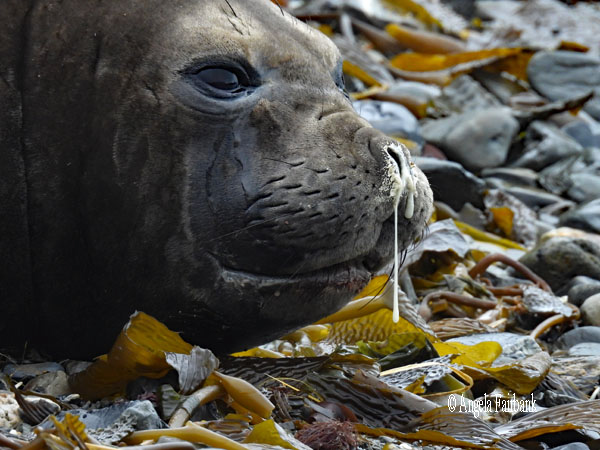 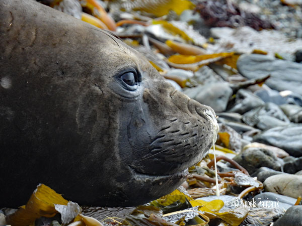    Landing on a rocky beach, we were invited to explore in three directions. The first was to the left along the beach, which led to several Antarctic Fur Seals (Arctocephalus gazella) in the water, on the beach, and lying in the tussac grass. At the end of this stretch, and on the other bank of a stream that was too deep for us to wade through, we saw these few King Penguins (Aptenodytes patagonicus), most of which were preening themselves or picking off the remaining moult. Their low numbers were disappointing, but their colours were bright. I then returned the way I had come, passing a single Gentoo Penguin ( Pygoscelis papua) and walked to the other side of the beach where we saw more fur seals, including large golden-coloured males, sleeping among the grasses, and then two huge female Southern Elephant Seals (Mirounga leonina), which sadly had no trunks but did have snotty noses. Playing among the pod of fur seals here was an albino pup, frolicking with his black-furred siblings and friends. We also photographed a South Georgia Pipit (Anthus antarcticus) here, scavenging amongst the rocks and seaweed. Our third path was uphill along a marked trail among the tussac grasses to see and photograph more seals and get an overall view of the place. Some of the younger seals on the shore would tend to wander up to us out of curiosity, but it was suggested we carry a walking stick and hold it out toward the individual seals with the pointed end in the ground to warn them off and this strategy seemed to work. They would approach no further and head back to whence they had come.
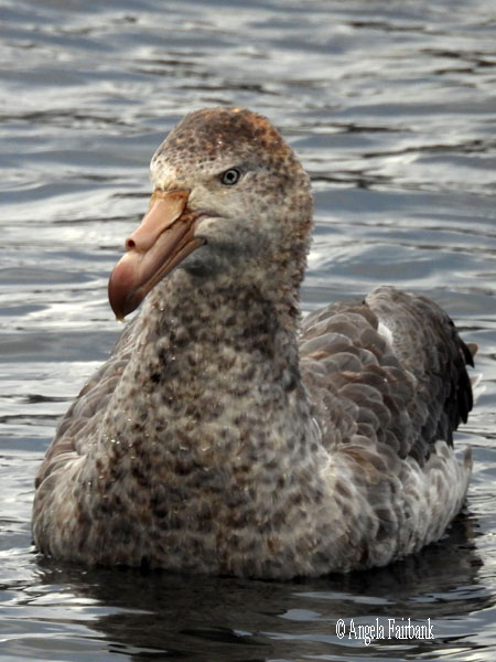
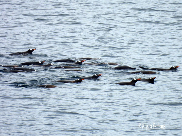
            On my return to the ship, I immediately transferred my photos to my laptop and started editing them, consequently almost missing lunch, so engrossed was I. After lunch, I noticed some activity in the water as we were sailing toward our next landing site, Godthul, which included these Antarctic Prions (Pachyptila desolata), swimming King Penguins, and this Southern Giant Petrel (Macronectes giganteus), also known as the Antarctic Giant Petrel, Giant Fulmar, Stinker, and Stinkpot. Why the latter two names, you ask? Apparently, it is primarily due to its habit of ejecting a foul-smelling, oily fluid as a defence mechanism. Both adults and chicks can projectile vomit a rancid stomach oil at potential predators or humans who get too close to their nests. Aggressive scavengers, they frequently feed on decaying seal and whale carcasses, and accordingly, their bodies and plumage often carry an intense, putrefying odor. The name was popularized by 19th-century sailors and whalers who were often repelled by the bird's smell and aggressive nature. Here's hoping I never get too close to one.
        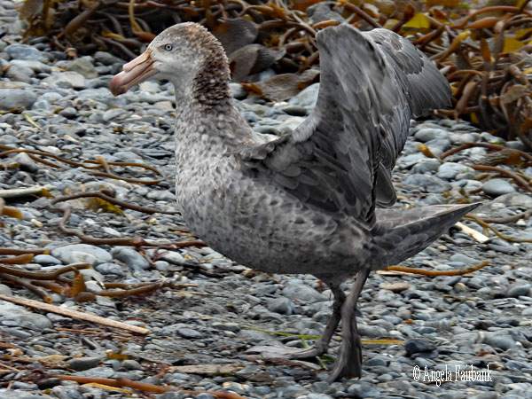                         We were the penultimate group to go onshore and were lucky with the weather because during the earlier group's visit, it had been raining. We had a dry landing therefore and although we did not see any king penguins here, there were lots of gentoo penguins, fur seals, elephant seals and, what do you know, a giant petrel! The latter flew overhead, landed in the sea, swam towards the shore, ran across the beach and into the tussac grass, and sat beside an adult fur seal. The female seal didn't seem to like this intrusion, although the giant petrel wasn't doing anything but sitting calmly, and clearly told it to leave. Back across the beach it walked, or ran, and took to the sea once more. It certainly had beautiful plumage and I did not notice any putrid smell coming from it.
                              Sunday, March 8, 2026: Salisbury Plain (54.050° S, 37.350° W) and Prince Olav Harbour (54.0667° S, 37.1500° W), South Georgia
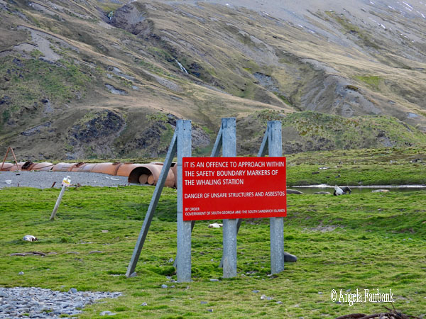
We woke up to strong winds, sideways-blown sleet and poor visibility, and consequently, were unable to take the zodiacs out, let alone land on what would have been our pièce de résistance among landings in South Georgia, Salisbury Plain, said to be inhabited by hundreds of thousands of king penguins. Instead, we were able to see them swimming in the water because as our ship turned in the water to try to position itself, it churned up food for the penguins, and they were cavorting and swimming and eating in joyous rapture. Due to the intense wind and sleet, the outer decks were cordoned off, and our only option was to try to photograph these creatures in the water through slightly coloured glass. None of my cameras were capable of getting great shots. No doubt the ship's photographer, who has carte blanche of the ship, did, however, so perhaps we will see these in the final photo slideshow. There were a few blurry glimpses of the mainland during brief moments when the mist and sleet cleared slightly, but we were too far away for my camera to capture anything remotely sensible. This landing was therefore cancelled and we motored back down south to Prince Olav Harbour where we will be unable to land due to the fact that it was once a whaling station and still contains asbestos from collapsing buildings and some other dangers to us, such as flying sheet metal from the fierce winds. We are supposed to be doing some zodiac cruising, however, but it all depends on whether the weather clears up enough. Around 3:00 p.m., we were invited to a short celebration with cake for International Women's Day. Our female staff captain from Croatia gets command of this ship in April then will share command with the current male Norwegian captain for a month each in turn. Around 5:00 p.m., our group was the first to be called for zodiac cruising in biting snow flurries, where we saw plenty of kelp gulls, white adults and black juveniles, as well as kelp, hundreds of fur seals in the water along with a few Gentoo penguins, after passing a ghost town of an ancient whaling station that was rusting. Then we drove to a lagoon, inside of which we saw about 4 king penguins walking along the shore, lots and lots of fur seals cavorting, about a half dozen giant petrels, one or two juvenile cormorants, and more gentoo penguins. The snow was settling on the deck of the zodiacs, so we made a few snowballs and tried to throw them at other zodiacs, but our aim wasn't long enough and consequently, the balls just fell in the water. 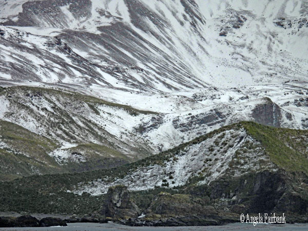     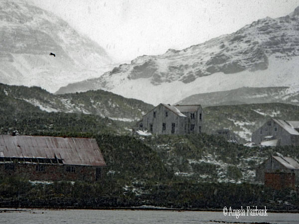  Monday, March 9, 2026: Fortuna Bay (54.1049° S, 36.7942° W) and Stromness Bay (54.1604°S, 36.6375° W), South Georgia
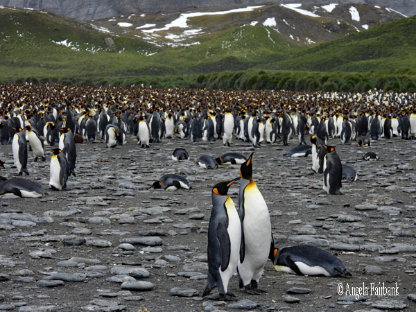
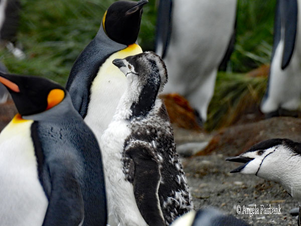
Despite the snow that had fallen by the time we arrived in Fortuna Bay (see the first photo below), it had thawed by the time we, as the second group, went on land and my dreams were fulfilled in that there were thousands upon thousands (est. 14,000) king penguins (plus moulting youngsters) to photograph along with more fur seals, which we practically ignored, poor them. I also took several close-up photos of brown skuas (Stercorarius antarcticus) as they were so tame, and a giant petrel chick. There are quite a few series of photos among the ones here as I followed particular penguins in their courtship rituals, including quite chummy penguin couples and a trio consisting of two male penguins both interested in the same female. They followed behind her as she acted coquettish and rejected their approaches. It was a fascinating and riveting experience, watching (fairly closely in some instances) king penguin behaviour. And oh, the colours!     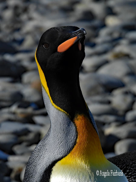 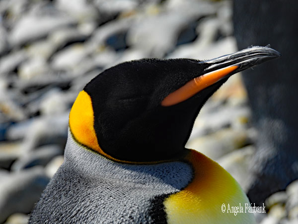  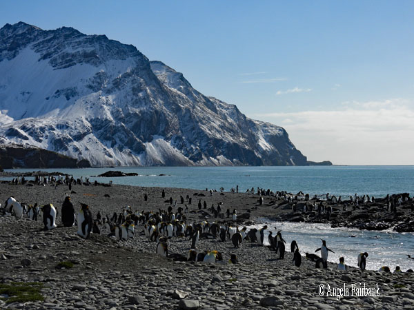   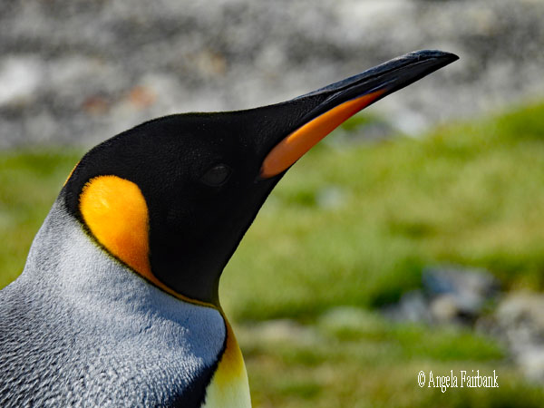 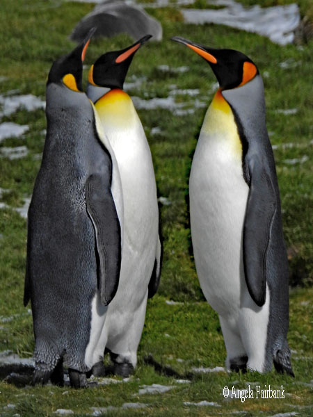     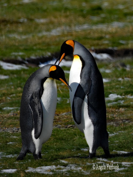 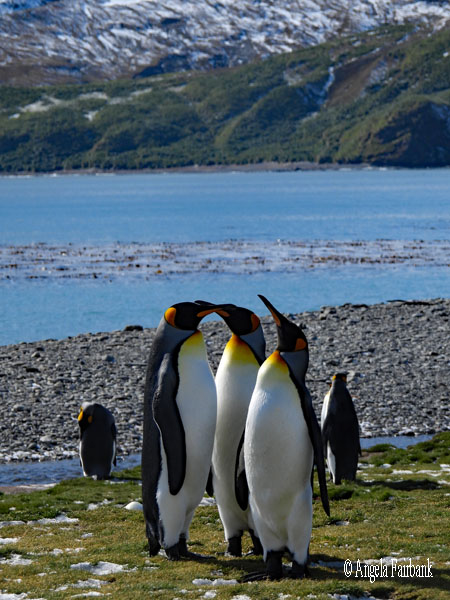 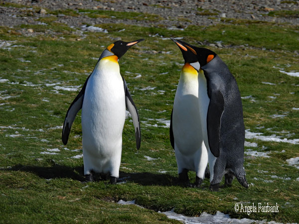    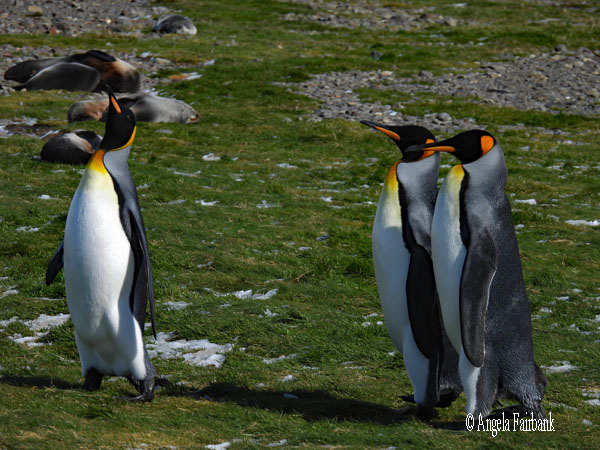  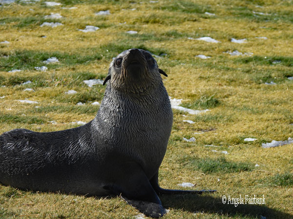 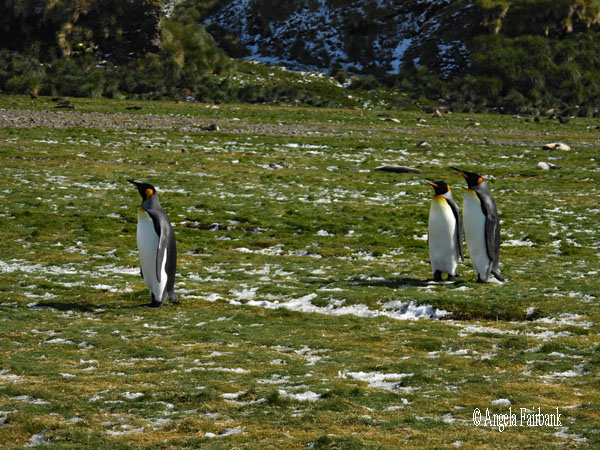      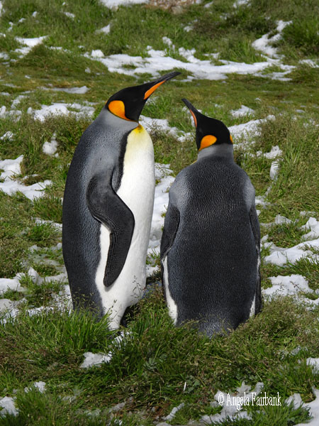       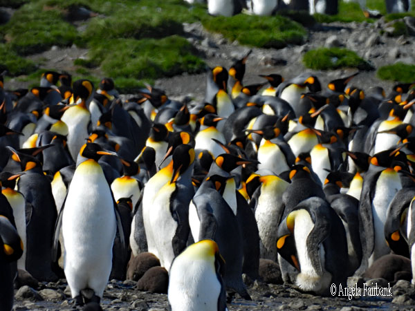        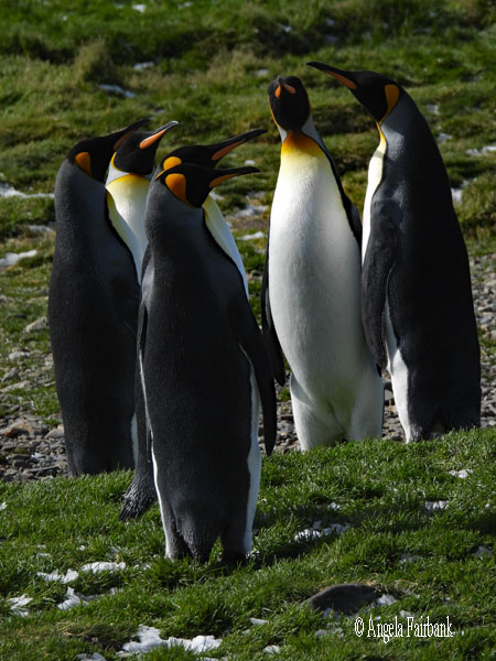 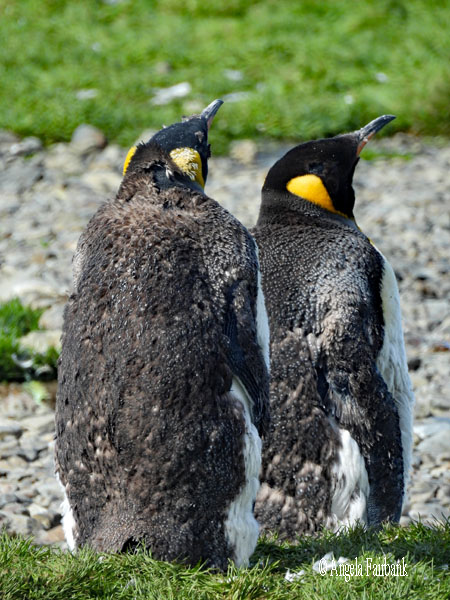    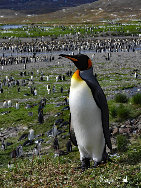      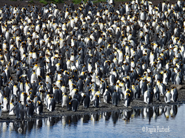       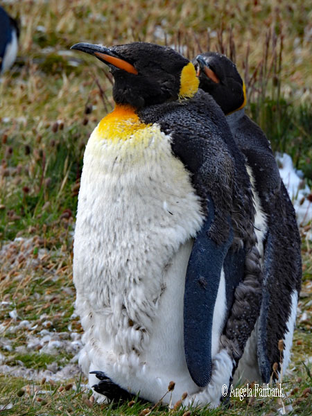 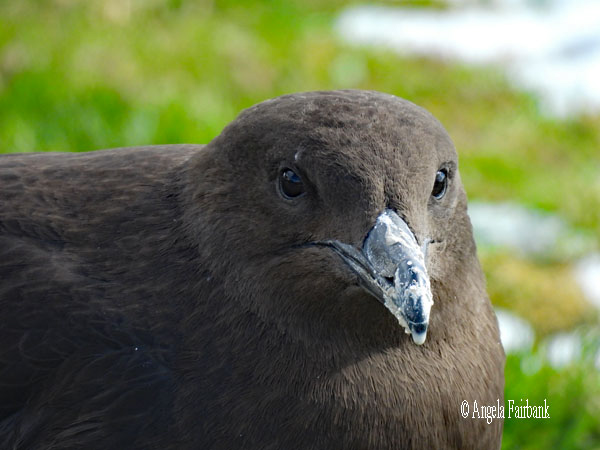  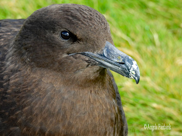     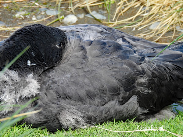  In the afternoon, after seeing another southern right whale come close to the ship, we had a second landing at Stromness, an ancient whaling station, which we could not enter, but in addition to many fur seals, which I was able to photograph at the end of the day when the light was lovely, and about eight sleeping elephant seals, there were also a few king penguins, gentoo penguins, a giant petrel, and I took some successful videos. It was quite a successful day, all told.
                                                Tuesday, March 10, 2026: Hercules Bay (54.1239° S, 36.6670° W) and Grytviken (54.2811° S, 36.5087° W), South Georgia
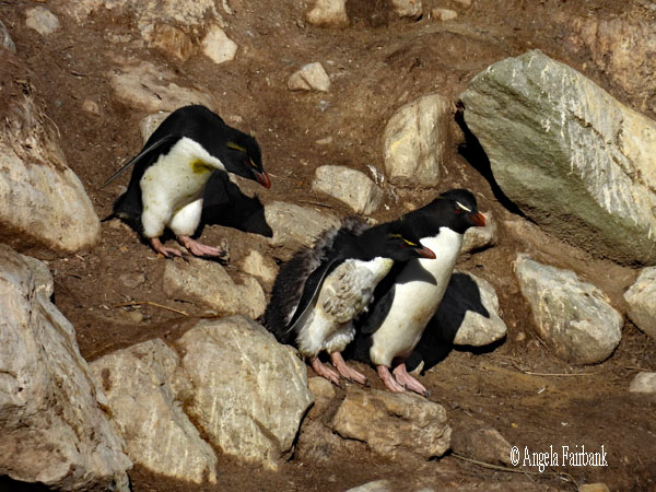
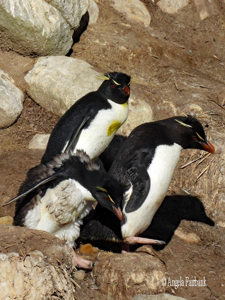
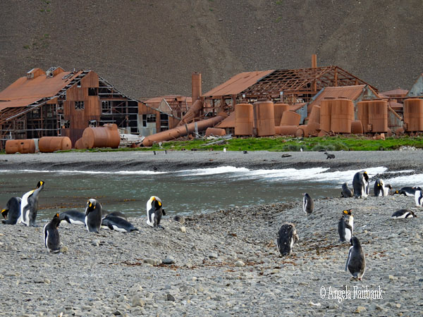
Today we were promised Macaroni Penguins (Eudyptes chrysolophus) and the ship (and South Georgia) delivered ... together with a few Gentoo, Chinstrap (Pygoscelis antarcticus) and King penguins, plus elephant seals, fur seals, Antarctic Terns (Sterna vittata), Snowy Sheathbills (Chionis albus.), Kelp Gulls, Giant Petrels, and Brown Skuas, all while we were cruising in zodiacs. We were in a place called Hercules Bay and it was absolutely beautiful in the sunshine. I'll give you a break from reading today so you can just look at the photos...probably too many but we were told that this was our only chance to photograph macaroni penguins so I might possibly have gotten carried away!      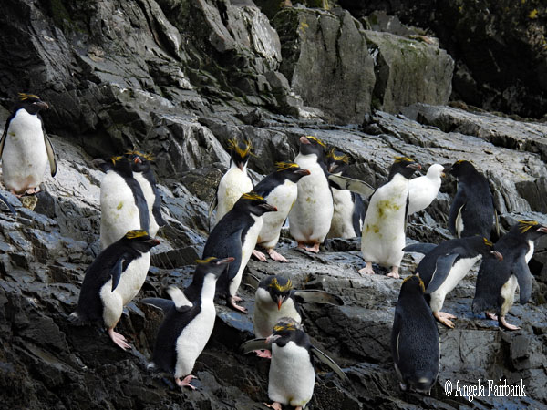     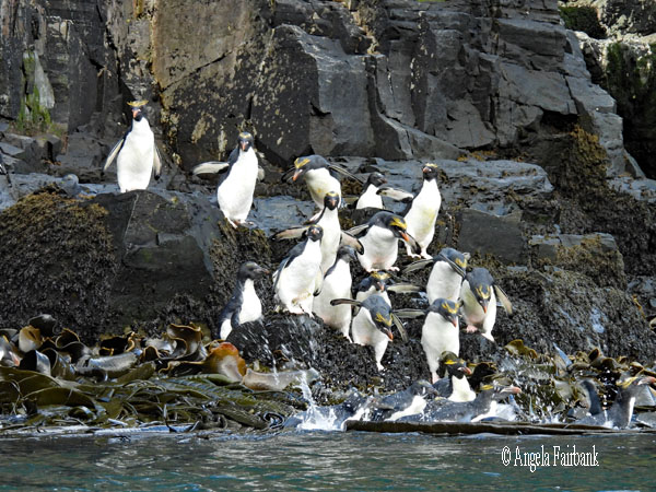 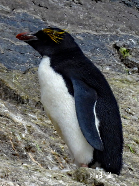     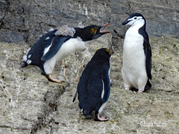 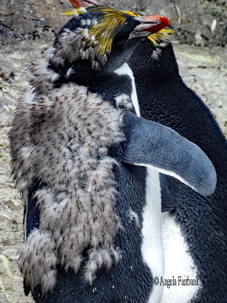 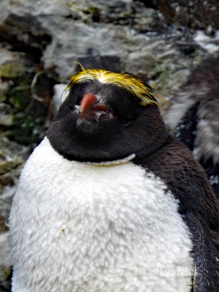      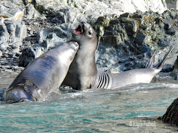 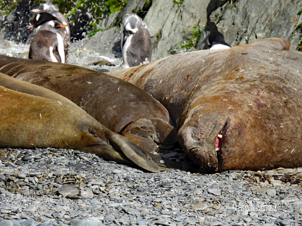   In the afternoon around 2:30, we arrived in the bay where the capital city, Grytviken, lies, and took zodiacs to the land. First, we visited Sir Ernest Shackleton's grave, where the ship's historian read out a speech about him, information that was entirely new to me, and we toasted the man with Scottish whisky from the ship. She later copied the speech out for us, and I shall reproduce it here so you too can learn who Shackleton was, in case you've never heard of him:
“Ladies and gentlemen, We are standing today at one of the most powerful places in the history of polar exploration. Before us lies Sir Ernest Shackleton. Shackleton did not die in the ice. He did not perish heroically on a sledge journey, nor vanish into the white silence of Antarctica. Instead, he died suddenly, in the early hours of January 5, 1922, aboard his ship Quest, anchored just here in Grytviken harbour. He was 47 years old. Shackleton is remembered not because he reached the South Pole. He is remembered because of something much rarer: leadership under absolute failure! His ship, the Endurance, was crushed in the Weddell Sea ice, and yet every single man survived. Not through luck, but through decisions made day after day, under pressure, cold, hunger, and fear. Shackleton understood something fundamental: Exploration is not about success at any cost; it is about responsibility. When the goal became impossible, he abandoned it without hesitation. From that moment on, his only mission was to bring his men home. The journey that followed--the drift on the ice, the open boats, the landing on Elephant Island, and finally the small boat James Caird crossing 1,300 kilometres of the Southern Ocean to reach this island--was an act of refusal. A refusal to give up his comrades. When we stand here today, we are not just remembering an explorer. We are standing at a reminder of what leadership can look like when everything goes wrong. Shackleton once said, 'Optimism is true moral courage.' Cheers to the boss!” Then we were left to our own devices to meander around the coast, past more fur seals, king penguins, and yet more fur seals, to visit various rusting buildings left by the whaling industry, the museum and its shop, the toilets, as well as the post office and its shop, where I bought a t-shirt and a magnet. My final visit was to the church built in 1913, in which, surprisingly, most of the information seemed to be in Norwegian (the hymn book left on the organ for instance), which perplexed me as I thought the Island belonged to the UK. I must say I was underwhelmed with the site in general, perhaps simply because I was not a historian or had any interest in whaling. As a consequence, I left the mainland early to return to the ship and worked on my usual photos and text. Nonetheless, to satisfy the curiosity of the history buffs among you, I did take photos of information boards in the museum, which I shall reproduce below.    “In 1786, the first sealing ships arrived in South Georgia. By the beginning of the nineteenth century, over fifty sealing vessels were working around the coast, exploiting the Antarctic fur seal. The harvest was plentiful, catching upward of 10,000 fur seals per season for their skins. Sealers found a lucrative trade, but by 1823 the beaches of South Georgia had been virtually cleared of fur seals. Attention turned instead to ... Southern elephant seal[s], hunted for their blubber until about 1965. The depletion of their numbers meant that sealing became unprofitable. Only a few sealing vessels survived into the twentieth century, with the last operating in 1913.
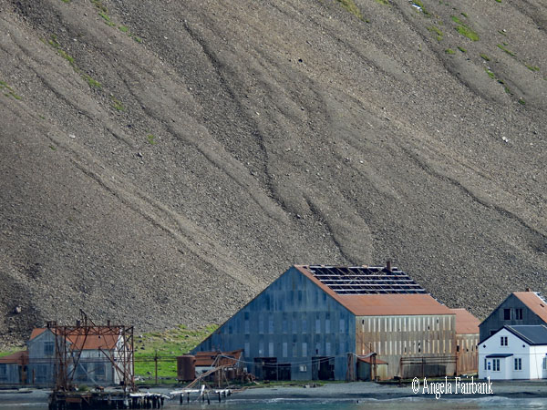
   Captain Larsen, a Norwegian whaler and sealer, first visited South Georgia on the Swedish South Polar Expedition in 1902. He noted an abundance of whales in the southern waters. Knowing that he was onto a goldmine, Larsen applied for a British whaling lease. Using Argentinian capital, he founded the whaling company Compañia Argentina de Pesca, establishing the first whaling station at Grytviken. Arriving at the site in 1904 with a new steam-powered whale catcher, Fortuna, and 65 men, Larsen built a shore-based station. Within six weeks of their arrival, they had processed their first whale on December 24, 1904. In the first season, 183 whales were caught and processed, pioneering commercial whaling in the Southern Ocean. The venture was so lucrative that by 1911, eight whaling companies operated seven stations in South Georgia. For the next 50 years, whales were hunted extensively throughout Antarctic waters.
   A Manager's Villa was built for the senior members of the whaling station staff and visiting family members. The house was centrally heated, electric light was provided by the hydro-generator and there was a telephone connection to the factory. In 1911, it was extended and a note from a resident describes it having 'luxuriant potted plants,' and of 'eight-course meals being served by a butler.' In 1914, the villa was burned down to be replaced in 1916 by the current building, which now houses the museum. Altogether, six shore stations were established on South Georgia, along with a station for factory ships. The stations Stromness, Husvik, New Fortuna Bay, and Godthul were Norwegian, Prince Olav Harbour and Leigh Harbour were British, and the factory site here in Grytviken was Argentinian. Grytviken was populated by mainly Norwegians but crew lists show that the workforce on South Georgia was made up of many nationalities.
   The life of a whaler could be tough. Two hundred and forty-seven deaths were registered on South Georgia between 1904 and 1962. Some were whaling accidents, others from disease. In 1912, an outbreak of Typhus killed nine men at Grytviken. Funerals were held at Grytviken church, which was prefabricated in Norway and shipped down for construction in 1913. The first pastor admitted that 'the religious life among the whalers left much to be desired.' The whalers instead found other ways to entertain themselves. The carving and decoration of whale teeth was a common pastime. Music, reading, and drinking were also ways to spend an evening on station. Sport was hugely popular among the whalers. The stations at Grytviken, Leith Harbour, and Husvik took turns at hosting winter games and football tournaments. Still visible in Grytviken today is the football field and the remains of the ski jump on the hill behind the church.
There were specialist workers for every part of the operation, from stripping the whale of its blubber, to operating the press boilers, to bagging powdered whale bone. Due to their isolated location, the whaling stations of South Georgia had to be completely self-sufficient. Here at Grytviken this meant that a vast number of tradesmen were employed to carry out a wide range of tasks. There were engineers, welders, riveters, blacksmiths, carpenters, painters, and electricians. Purpose-built and well-equipped workshops around the station ensured that the factory and the whale catchers were in working order. The men worked from six in the morning until six at night. There was a half hour break for breakfast at 8:00 a.m., an hour for lunch at 12:30 p.m., and another half hour break for coffee at 3:00 p.m. Overtime pay for working on Sundays was 50%, so many men worked seven days a week.
   As more efficient alternatives to whale oil were found, whaling was in decline. Kerosene and petroleum replaced the need for whale oil in fuel and illumination, and vegetable oils replaced the need for hydrogenated fats in foods. Severe pressure had also built up on Antarctic whale stocks. By the 1950s, blue whales were exceedingly rare, forcing catchers to sail ever further in search of Antarctic whales. Attitudes towards whale oil were also changing. Organizations such as Greenpeace began confronting whaling ships in the North Pacific, raising awareness among the public of whaling practices. In 1964, Grytviken whaling station closed for good. The land-based whaling industry on South Georgia finally ended with the closure of the last working factory at Leith Harbour in 1965. A total of 175,250 whales were killed in the waters around South Georgia. In 1982, the International Whaling Commission voted to pass a moratorium on whaling. In 1994, the Commission created the Southern Ocean Whales Sanctuary, a 50-million-square-kilometre area surrounding Antarctica. Hopefully, these measures will see a recovery of whale populations to pre-whaling levels in South Georgia.”
 Wednesday, March 11, 2026: Gold Harbour, South Georgia (54.6265° S, 35.9421° W) and then At Sea
Since we'd had that awful weather and were unable to land in Salisbury Plain on Sunday, March 8th, our expedition team leader and captain made it possible for us to make one more landing in South Georgia today, in Gold Harbour, before leaving this beautiful part of the world and heading south toward Antarctica. Gold Harbour is a small bay 5 miles (8 km) south-southwest of Cape Charlotte, with Bertrab Glacier at its head, along the east end of South Georgia. It was given this name because the sun's rays, according to Wikipedia, make the cliffs yellow with their light in the morning and evening. The area is a breeding ground for penguins, including King Penguins and Gentoo Penguins. Southern Elephant Seals also breed here, especially at the west end of the beach, where a glacial stream flows. 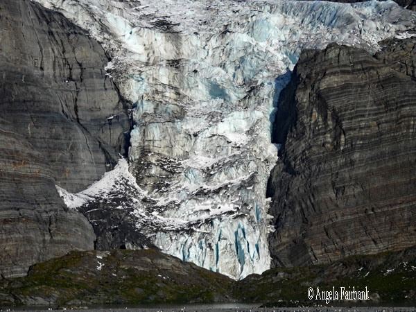 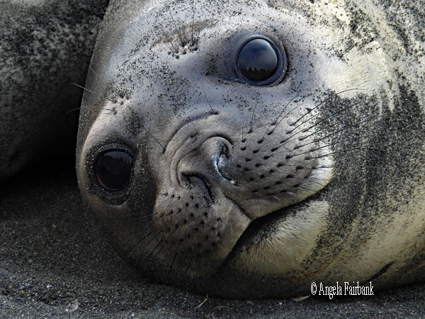 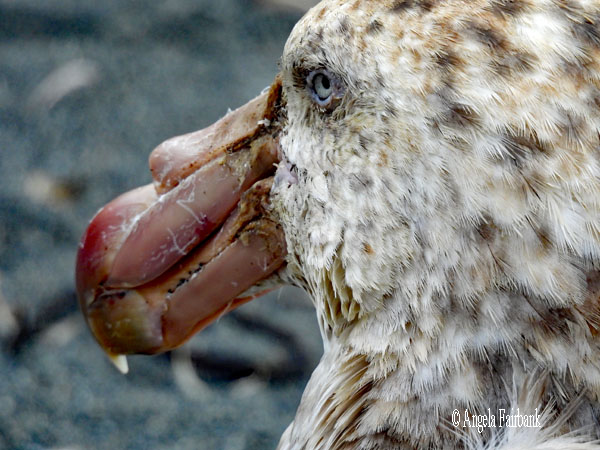                  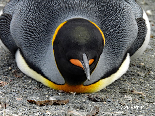 
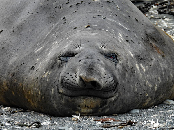
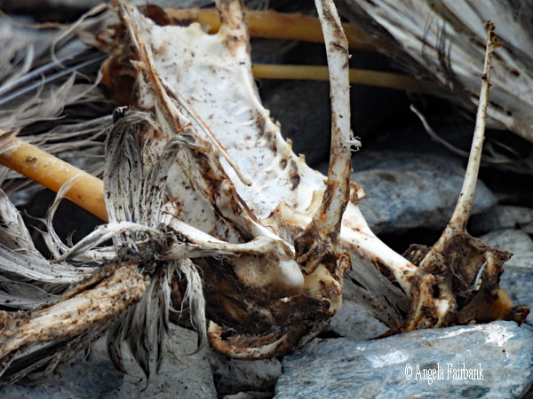
           Given the high numbers of wildlife on the beach here, we were taken on land by zodiacs two groups at a time instead of three. Nevertheless, it was a magical place, and despite having seen masses of king and gentoo penguins already, not to mention fur seals, plus a few chinstrap penguins (you will see among my photos two youngsters moulting), we saw a bit more moulting going on here, plus a few more brown skuas, giant petrels, and snowy sheathbills, scavenging or waiting for weaker penguins to become separated so they could leap on them and snatch them away. There was also a nicely laid out example of an elephant seal skeleton that must have been there for quite a while as it was picked clean. However, the new photo opportunity here was represented by the large piles of sizeable male elephant seals lying on the land with their noticeable mini trunks and photogenic smiling faces. Some of them were massive in size (and no doubt weight) yet somehow, they had managed to pull themselves out of the sea. Time passed way too quickly in this place. We felt we could have spent hours here, yet the clouds were descending, and we did need to get away so as to reach our next destination on schedule. As a result, once again, we had to pull ourselves away very reluctantly, get back on our zodiacs, and return to the ship. Good-bye South Georgia. You are a magnificent place for wildlife and highly recommendable!
                                     Thursday, March 12, 2026: At Sea, Scotia Sea
I kept oddly busy today. First, we had a lecture on the IAATO (International Association of Antarctica Tour Operators), which advocates, promotes, and practices safe and environmentally responsible private sector tourism to the Antarctic. As we were entering fresh territory, and therefore in an endeavour not to bring in any seeds etc. from South Georgia, we had to sanitize our outerwear and boots again. I also attended a briefing on kayaking and signed a waiver so I could paddle myself in an inflatable kayak in a couple of days. As I think I mentioned earlier, I have twice before tried joining a kayaking activity with HX in the Arctic or Antarctic, but both times my plans were thwarted due to the seas being too rough for the time slot for which I was scheduled. Third time lucky perhaps. But the activity that took up most of my time and energy today was a scavenger hunt where we had a list of 25 items on the ship to find and photograph, or video, and then identify baby pictures of seven of the sixteen expedition members. Our skill testing question, should there be need for a tie breaker among our six teams, which I doubt as one team was certainly stronger, was to guess the cumulative age of the sixteen expedition members. We shall know the results after this evening's briefing about what is planned for tomorrow. After that was done, I was able to join the end of a Q & A session with four scientists to whom the Fram was giving a lift from the Research Station in Grytviken, South Georgia to the Research Station in Signy, South Orkney Islands. All of these scientists are British, and one is a brand-new doctor for the station. Signy Island is a small (19 to 20 km2) sub-Antarctic island in the South Orkney Islands, located south of the larger Coronation Island. Administered under the Antarctic Treaty System, it hosts the British Antarctic Survey (BAS)'s Signy Research Station, established in 1947. A hub for studying climate change, environmental science, and seabird/seal populations, it operates in the summer season only to study marine and terrestrial ecosystems, including penguins and seals. The sea remained choppy all day and the sky stayed covered with low-hanging clouds, so I took no photos (other than those for the scavenger hunt). As for the results of the latter, the top team had 27 points. As for the other five teams, three of us had the same score of 25 points. However, I guessed way too low when it came to the tie-breaking questions of the cumulative ages of the 16 expedition team members, so I ended up in fourth place. I was happy with that since I had done the entire thing on my own while the other teams were made up of 5 or 6 players each.  Friday, March 13, 2026: Signy Island, South Orkney Islands (60.6000° S, 45.5000° W) and then on to Antarctica
We have sailed across the 60-degree-South line and are now officially in the Antarctic Ocean. We were privileged to be able to visit the Research Station in Signy, South Orkney Islands, today. It was touch and go yesterday and last night with gale-force winds and we were not sure if we would make it. But we woke up to clear skies and icebergs galore, having sought shelter among the eastern outer smaller islands last night, and coming south and around to the island of Signy. So as not to repeat what I wrote yesterday, the South Orkney archipelago is made up of four major islands: Coronation, Laurie, Powell, and Signy, located in the Southern Ocean, more specifically in the Scotia Sea at the North-Eastern tip of the Antarctic Peninsula about 604 km (375 mi) north-east of the tip of the Antarctic Peninsula and 844 km (524 mi) south-west of South Georgia Island. They have a total area of about 620 km2 (240 sq mi). The islands are claimed both by Britain (as part of the British Antarctic Territory since 1962, previously as a Falkland Islands Dependency) and by Argentina (as part of Argentine Antarctica). Under the 1959 Antarctic Treaty, sovereignty claims are held in abeyance. 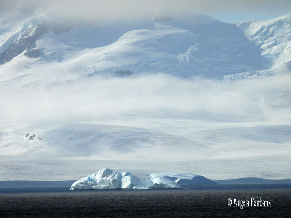   Curious, I asked AI what the difference between the Southern Sea, the Antarctic Ocean, and the Scotia Sea were and it was explained thusly: “The Southern Ocean is the formal fifth ocean (south of 60°S), while the Antarctic Ocean is an alternative name for the same body. The Scotia Sea is a smaller marginal sea on the Southern Ocean's northern edge between South America and Antarctica. The key difference is that the Southern/Antarctic Ocean is the entire circumpolar body, while the Scotia Sea is a specific, smaller boundary area.
   In any case, I found out that the South Orkneys are not part of the British Overseas Territories as both Britain and Argentina maintain bases on the islands. Apart from the British Research Station at Signy, mentioned under yesterday's entry, the Argentine base, Orcadas, established in 1904, is situated on Laurie Island. The 11 buildings of the Argentine station house up to 45 people during the summer, and an average of 14 during winter. Apart from personnel at the bases, there are no permanent human inhabitants on these islands. And, I think I mentioned earlier in this travelogue, Argentina claims sovereignty over both the Falklands and South Georgia and the South Sandwich Islands.
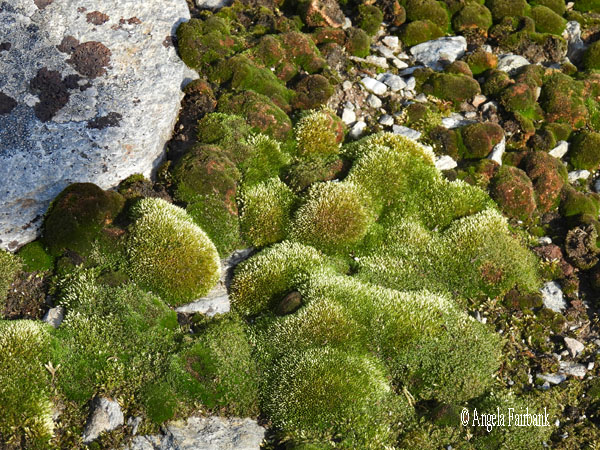
   We arrived at Signy around 2:00 p.m. and since so few of us were allowed on shore at one time, so as not to overwhelm the eight seasonal researchers there, we were divided into zodiacs, and I was in the third zodiac, which left the ship at 3:00 p.m. It was another gorgeous day as we motored past rock islands, glaciers, and a few flying Antarctic Cormorants, and arrived safely on the research station's jetty to be met by one of the researchers, who'd been coming down to work at this station for the past eight years and before that had been working at the research station on Bird Island in South Georgia. He pointed out the various buildings for food storage, generators, storage tanks for hazardous materials and infectious materials, etc. and then took us inside the living quarters where they have four rooms with two single bunks in each and a shared bathroom. Although these latter rooms were not made available for viewing (to my chagrin), we were permitted to see their kitchen and living room in addition to some of the offices and take photos. Then we were taken on a loop walk up to a promontory, from where we were able to photograph the sea around, the cliffs, where I photographed one chinstrap penguin and two young brown skuas at some distance, and the moss that was the main vegetation. Not many members of the public actually get to see research stations, so we felt very privileged indeed, and, of course, it meant I was able to add one more group of British islands to my list. The South Orkneys are described on one website as “one of Antarctica's most elusive destinations” and by another as “among the most remote and least-visited places on Earth, making them a true gem for adventurous travellers and wildlife enthusiasts.”
 Funnily enough, I was reminded of a children's book called Marcus Superpenguin to the Rescue! by A.P. Hernández that I had translated in 2024 from Spanish where the main character is an Emperor Penguin who visits a research station called Concordia in Antarctica. Concordia Research Station is a French-Italian facility located at Dome C on the Antarctic Plateau in East Antarctica, sitting at an elevation of 3,233 metres (10,607 ft) above sea level. It is located over 1,000 km inland from the coast and 1,670 km from the Geographic South Pole, so quite far from where we are now. The underlying theme of this children's book is, not unexpectedly, global warming.
Saturday, March 14, 2026: At Sea, Powell Basin After a rather rough night of rocking and rolling, our scenery remained relatively grey today for both sea and sky and I felt a cold coming on. I did attend the presentation for the Antarctica camping activity but decided it was not for me. I figured if I'm paying that amount of money (Euros439) for a little under 8 hours, most of which time one is expected to be asleep, I'd rather be in a warm, luxury hotel with ensuite bathroom, and not be required to dig my own hole, set up my own tent, blow up my own air mattress, and use an emergency toilet set up in the middle of a snow bank with absolutely no privacy. For the rest of the day, I worked on my book translation and managed to complete a couple of chapters. Sunday, March 15, 2026: Telefon Bay, Port Foster, Deception Island, South Shetland Islands, Antarctica (62.9466° S, 60.6840° W)
Around 11:00 a.m. today, we were invited to go out on deck and watch and photograph as we drove through Neptune's Bellows and into the ring-shaped flooded caldera of an active volcanic island, called Deception Island, in the South Shetland Islands of Antarctica. The channel is said to be treacherous due to its narrowness and Raven Rock, a submerged rock lying only 2.5 metres below the water in the middle of the passage, which has caused shipwrecks. The name of Bellows is due to the strong, gusty winds often experienced in the narrow passage, to which I can attest. After exiting the passage, we turned right into Whaler's Bay (the subject of the photos below), on which I remember landing in November 2024. At that time, of course, it was the beginning of the summer season and was covered in snow. Today, it seems slightly incongruous to be in Antarctica and see bare mountains and bare lava sand shores. My cold has bloomed so I shall not be getting off the ship today via zodiac. We are only being offered a hike up to a rim over slightly treacherous lava sand, and the only wildlife here as far as I could see with my long camera lens were fur seals. At least we are in a different bay from last time, called Telefon Bay. A polar plunge is being offered here today too, although it is to be done from the beach at Telefon Bay, and not by jumping off a zodiac attached to the ship. Consequently, once more, I spent most of the day in my room working on my book translation. The sky is still grey and overcast, the air temperature, 3° Celsius and the water temperature, 1° Celsius.     Monday, March 16, 2026: Orne Harbour (64.6167° S, 62.5333° W) and Cuverville Island (64.6872° S, 62.6225° W) Antarctica
Now I feel we are in Antarctica. When I woke up this morning and opened my curtains on the port side, I saw white and blue snow on the mountains and icebergs in the water. When I went to breakfast on the starboard side, however, there was less snow on the rocky cliffs, but what was there was multicoloured: yellow, green, pink, brown, and some blue. An explanation for this will be found below. There were still some moulting Chinstrap Penguins as well as a few moulting Gentoos higher up, in addition to cormorants, snowy sheathbills, and one or two adult fur seals sleeping on rocks.     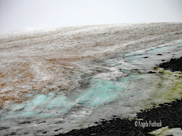  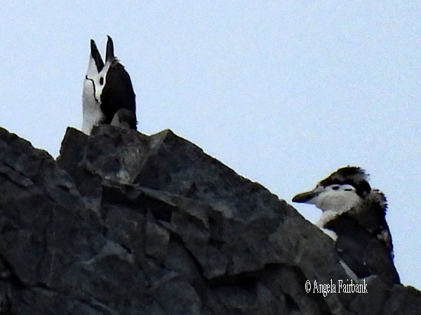 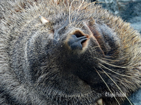  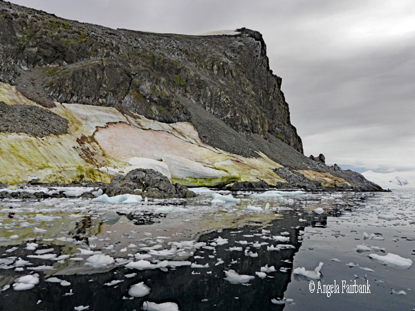    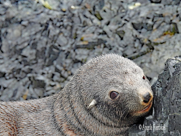 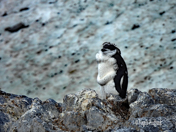 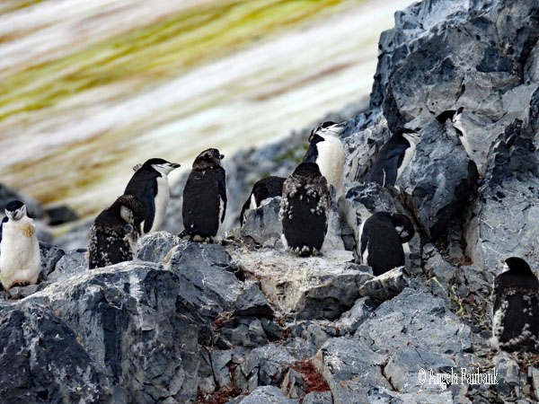   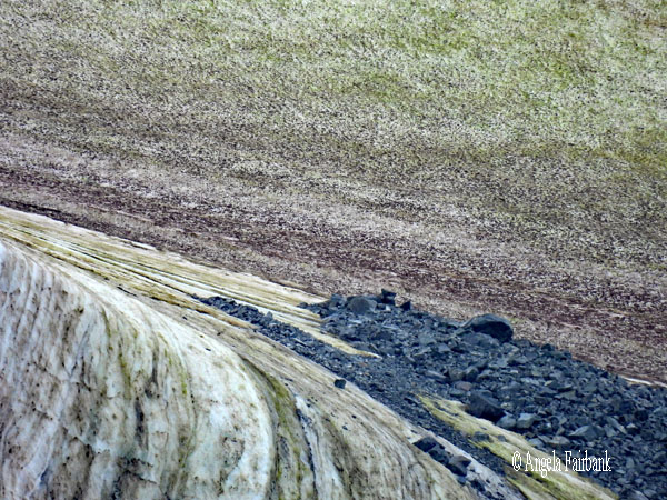    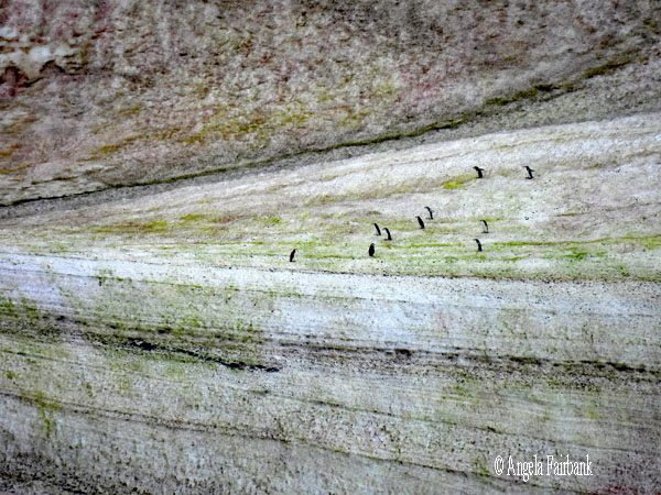 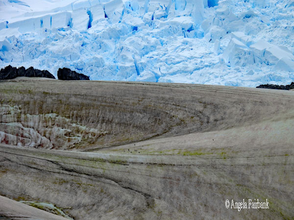    This was our first (and likely only) landing on the Antarctic Continent itself (the remaining landings planned being on islands), so once we arrived on land in our zodiacs, we were invited to have our photos taken with the Antarctic flag. Naturally, I accepted. There wasn't much land to walk on, as it was very rocky, with patches of mud, not to mention slippery red and white plankton and animal waste, so we mainly just stood in place and watched life going on around us as humpback whales shot their misty breath into the air and rolled around the water, penguins swam, the kayak group paddled around the far end of the harbour, and one or two of the ship's science boats collected samples of microscopic life for later viewing. The only sounds we heard (aside from a few passengers chatting) were loud cracks and thunders of the nearby glacier calving, the Chinstrap penguins calling to each other, their heads raised and necks stretched upwards, and the occasional grunting from adult fur seals. The sun poked briefly through the clouds early on but mainly hid from us while the water around our ship surreptitiously and gradually filled with brackish ice. Despite our short visit (perhaps 45 minutes) plus a 15-minute zodiac ride around the harbour to view and photograph more Chinstrap penguins, I managed to take 307 photos so now my task, as usual, is to cull them down to a more reasonable number.
                             After lunch, we had a second landing, this time on Cuverville Island, full of Gentoo penguins and one ravishing Adelie Penguin (Pygoscelis adeliae), our first this trip, thus completing our list of all of the types extant in this part of the world. We were told we were lucky to see an Adelie because they usually breed early on in the season and are now all out at sea. We were also told there were a couple of Leopard Seals (Hydrurga leptonyx) prowling the water in front of the beach and our official ship's photographer actually caught one in flagrante delicto in the act of grabbing a Gentoo penguin between its teeth. You will actually see the two photos in question at the end of our final ship's video of the voyage. It was fun to see the penguins and the South Polar Skua (Stercorarius maccormicki) taking closer looks at the blue cones used by the expedition team to mark the path we were allowed to walk on over the beach so as to avoid stepping on sleeping penguins. We also observed a penguin drinking from a small stream of melting snow running down the beach toward the sea. There were still a large number of moulting young Gentoos in their brown coats and even one we nicknamed the mohawk for his mohawk-like head due to a tuft of his moult still sticking to the back of his neck.
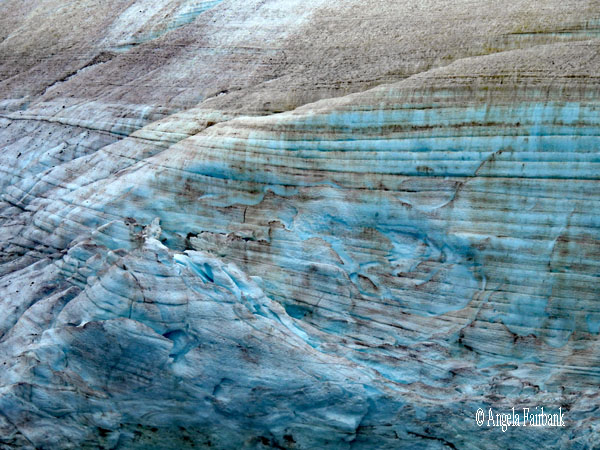
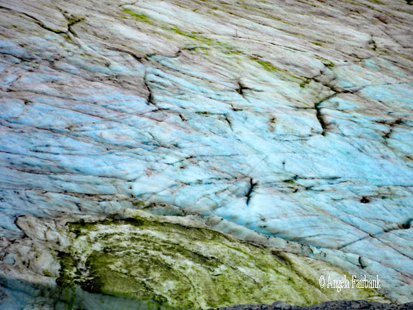
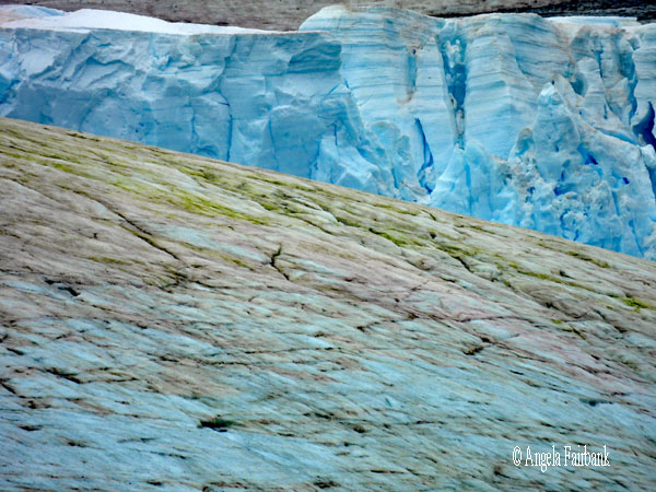
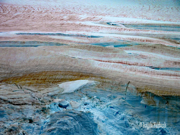
               You will probably notice in some of the photos from today the fact that the snow is not necessarily white, as we imagine Antarctica to be. And white was certainly the predominant colour when I last visited in early November 2024. However, we were told by our scientists that the red, green, yellow, and brown snow in Antarctica (particularly in March) are primarily caused by diverse types of snow algae that bloom on the surface of melting slush. Needing water to grow, they produce pigments, including green chlorophyll and red-orange pigments for UV-protection. Warmer temperatures cause more snowmelt, allowing the algae to thrive and spread, which in turn reduces the snow's ability to reflect sunlight accelerating further melting. According to a 2020 study, the blooms are so intense, they can be seen from space. The majority of blooms are found close to bird rookeries, particularly penguin colonies as well as seal haul-outs, so it's likely the excrement of these animals provides a large nutritious boost for algae growth. Needless to say, the pinkish guano produced by penguins from their krill-heavy diets can stain the snow pink as well and are the contributing factor to the aroma in these places. All in all, it was another wonderful landing for observation and photography, after which our zodiac driver took us around the harbour for a closer look at the various icebergs, humpbacked whales occasionally breaching, otherwise just floating around as they slept just beneath the ocean's surface so that we could see the tops of their backs and their dorsal fins, not to mention multiple floats of gentoo penguins swimming and leaping through the waves, etc. A small yacht was also present in the area.
               By the way, there was no camping in Antarctica for anyone today as there wasn't enough snow for the tents to be pitched. We also never got to kayak in the inflatable boats, although we were never formally given notice of the fact, so many of us were quite disappointed. Had we known this was not going to happen, some of us would have signed up for the rigid kayaks instead. The expedition team therefore fell short of our expectations in this regard.
            Tuesday, March 17, 2026: Lemaire Channel (65.1167° S, 64.0000° W), Petermann Island (65.1706° S, 64.1435° W) and Yalour Islands (65.233° S, 64.1667° W), Antarctica
Today was another full day of photographing as it was our last day in Antarctica and we were still hoping to see more Adelie Penguins, if possible. We were advised to get up for an early breakfast because we were going to attempt to pass through the Lemaire Channel, a 7-mile long, 1-mile wide passage with dramatic, steep cliffs, known for stunning, calm, mirror-like waters that are often filled with floating icebergs, its tight navigation and, at times, being impassable due to sea ice, often dubbed 'Kodak Alley.' I recalled that when I was here in November 2024, the Roald Amundsen could not in fact pass through it for this very reason. Instead, we had stayed inside the channel for a while to watch a pair of orca whales swim by our ship before the captain turned the vessel around and retreated the way we had come. This time, I would say all, if not at least most of us, were outside on the ship's bow together with most of the expedition team, ready to witness this feat, if possible. Unfortunately, the start of the channel was covered in low cloud and mist, not to mention that it was raining a bit, and there was a bit of a wind. However, over time, the cloud lifted, the rain ceased, and we could see the high cliffs to either side of us, in addition, later on, to plains of coloured snow, some with penguins in the far distance. I managed to photograph one group waddling down the mountain and then, later on, waddling up again. I took a short video of them at this point, and it appeared to me that they were Adelies. A leopard seal on a small piece of brackish ice was spied by the Expedition team, and I rushed behind a line of photographers all at the rail to get a clear view for my camera, but the animal chose to slide off the ice and into the water just at that point. However, I did manage to photograph it as it swam up and poked its head out of the water. Now we were at the end of the channel, where there were two large icebergs, one to our right and then, just a bit further on, a larger one to our left. You could have heard a pin drop as the ship pulled over to the left and then to the right, scraping against some ice in the process, which made a loud noise, but lo and behold we had made it through and a loud cheer of applause went up from us in the bow. As we clapped, we looked up at the bridge to see if they had noticed. They had and smiled. At the end of the channel exit, as we looked right to notice a few icebergs, one of the expedition team pointed out that this area was known as Iceberg Graveyard or Iceberg Alley because, due to the currents here, many icebergs get trapped and grounded, creating a dense 'garden' of stranded icebergs. To my mind, there did not seem to be as many in this spot as we had seen the last time I was here, perhaps due to them melting over the equivalency of two Antarctic summers. There were more humpback whales in these waters to watch as well.  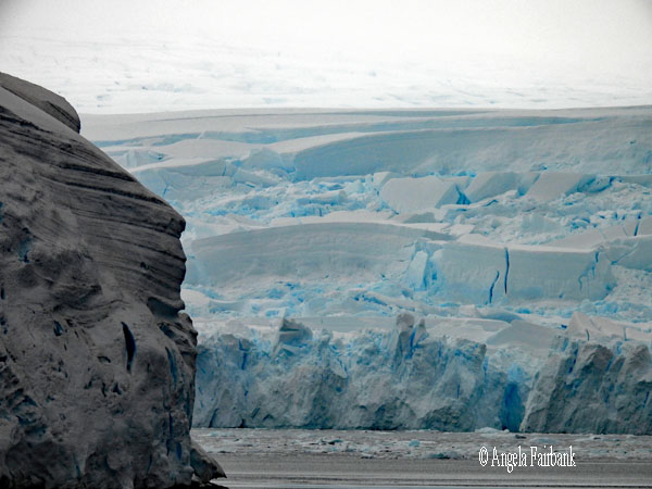 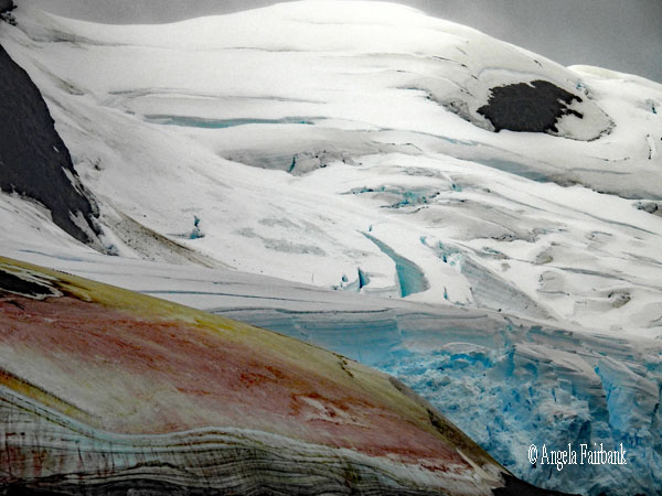            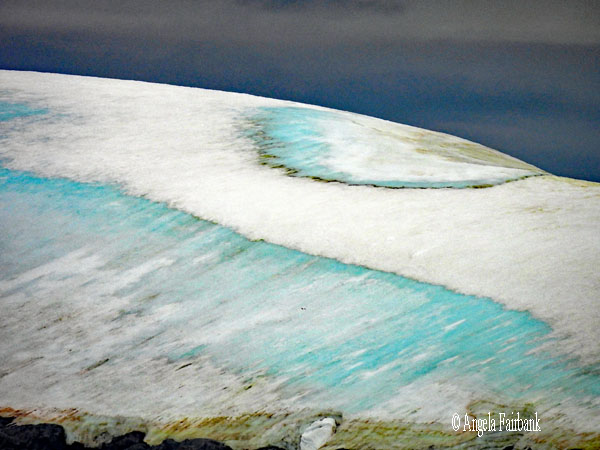     Soon after clearing the Lemaire Channel, we stopped at Petermann Island, earmarked to be our last landing site of this trip. Discovered in 1873-74, it was named after German geographer August Petermann. Jean-Baptiste Charcot wintered here in 1909 at Port Circumcision, named as such because it was spotted on January 1, 1909, the traditional day for the Feast of (Jesus Christ's) Circumcision. Huts built by the expedition are gone, although a cairn remains, along with a refuge hut built by Argentina in 1955 and a cross commemorating three members of the British Antarctic Survey who died in a 1982 attempt to cross the sea ice from Petermann to Faraday Station. A highly colourful island from all the aforementioned algae, I was excited to visit because I read there were Adelie penguins on it as well as Gentoos. It was also our only landing site still containing snow, although it was slushy and, in some places, slippery. The rocks we had to climb over to get to the slush were somewhat safer, not being slippery except where there was penguin excrement. I first photographed the gentoos at the hut containing a large Argentinian flag on its side wall, and then walked over to the snowy area and up a promontory where we could look down on the view. To get down again, I zigzagged with my one walking stick, past a Gentoo drinking water out of a stream running into a sort of gutterlike feature, and over to a pile of rocks where there was a total of six Adelies. They were awake and active and strutted about, much like other penguins do. However, the feature they have that the others we have seen do not, is that their eyes are quite spectacular. Instead of just the black iris you see covered by also black eyelids, or occasionally with a thin white rim at the edge of the eyelids I have noticed in Gentoos, these Adelies seem to have their irises on a background of white, like human eyes, although when I look up information about their eyes I am only told that adults have distinctive white rings around their eyes, while curiously, their chicks are born with black eye rings instead of white. Have a look at their eyes in the photos below or those of the single Adelie on Cuverville Island I photographed yesterday and perhaps you'll see what I'm getting at.
 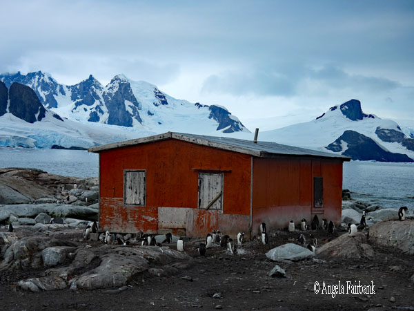
  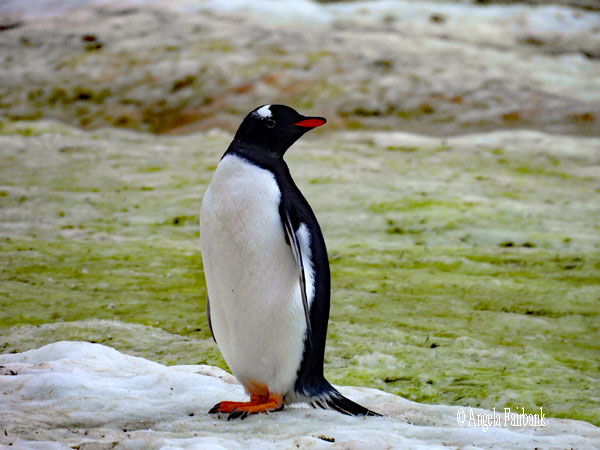     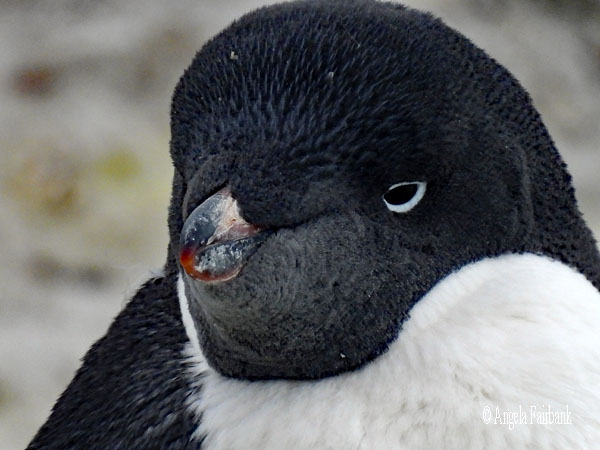    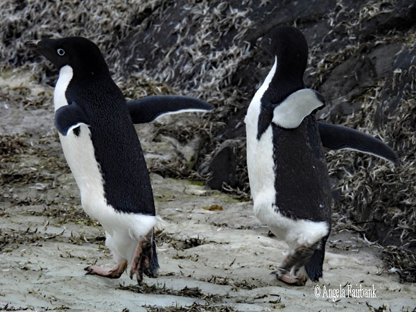          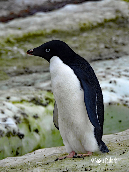    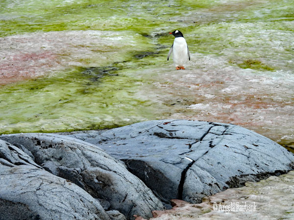   We were the last group to be called out on the zodiacs to Petermann Island and then the first ones to be called to our zodiac rides after lunch, so needless to say lunch was rushed and I just had time to transfer my photos from this morning over to my laptop when we were called. I wasn't expecting much from the zodiac cruising as it never presents ideal conditions for photography with the boat constantly moving. Nevertheless, we cruised around the Yalour islands, named for Lieutenant Jorge Yalour, of the Argentine Navy, an officer of the Argentine corvette Uruguay, which came to the rescue of the shipwrecked Swedish Antarctic Expedition in November 1903. I read that about 8,000 pairs of Adelie penguins nest in the Yalour Islands, but when I put my 2000mm camera lens up to my eye to look for them, I was disappointed to find only 14, at least on the shore we were facing from the ship. Our zodiac did take us past a few more, which I tried not very successfully to photograph. There were also a few blue-eyed shags (Leucocarbo atriceps). We had a humpback whale show us its tail twice (unfortunately I did not have my camera ready at that point). But more importantly we saw another leopard seal come right up next to our zodiac and hang around, but it only stuck its head up enough for us to see its nostrils, so I could not see how large it really was for such a reportedly frightening animal, according to the scientist steering our zodiac.
  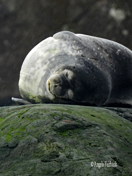 As we crossed through a passage of rocks over to another island or series of small islands, a fur seal came out of a dip in the rocks and showed itself to us, but more importantly, and even closer, were two Weddell Seals (Leptonychotes weddellii) sleeping on a couple of rocks, although only one of them was sufficiently interested to open its eyes and discover what was disturbing his sleep. As we drove around behind it, the zodiac got caught in the shallow water and never managed to catch up with its partner zodiac. I continued photographing this seal until the zodiac disengaged from the shallow water and the seal eventually became bored, rolled over, and went back to sleep. I was happy enough. I'd seen some more Adelies instead of just the six from this morning and the one from yesterday, and I'd managed to tick both the Leopard Seal and the Weddell Seal off my list of Antarctic animals to see and, more importantly, to photograph.
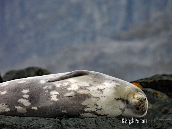   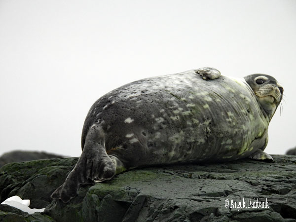  Arriving back on the ship, we were able to remove our extra layers of clothing and our boots for the last time and change into something more comfortable for we single passengers on this expeditione ship were invited to a special cocktail party at the stern behind the restaurant for prosecco and appetizers, hosted by the Croatian Hotel Manager and the Polish Executive Chef. We watched Antarctica recede as countless Humpback Whales drifted by, with a few showing us their flukes, not to mention penguins leaping in the waves. It was a picturesque and memorable send-off.
Wednesday, March 18, 2026: Drake Passage (59.9142° S, 62.3839° W)
Wikipedia tells us that the Drake Passage is the body of water between Cape Horn in Chile at the southern extreme of the South American mainland and the South Shetland Islands of Antarctica. It connects the southwestern part of the Atlantic Ocean (Scotia Sea) with the southeastern part of the Pacific Ocean. The passage is named after the 16th-century English explorer and privateer Sir Francis Drake. Traversing the Drake Passage is considered one of the most treacherous voyages for ships to make. The Antarctic Circumpolar Current, which runs through it, meets no resistance from any landmass, and waves can top 40 feet (12 m), giving it a reputation for being 'the most powerful convergence of seas.' Many of the passengers seem worried that we will experience what is known as a Drake Shake (rough seas) instead of a Drake Lake (smooth seas) but so far it has been rather lakelike. As the Drake Passage is the narrowest passage (choke point) around Antarctica, its existence and shape strongly influence the circulation of water around the continent and global oceanic circulation, and global climate. The bathymetry of the Drake Passage plays an important part in the global mixing of oceanic water. Part of the water body is named Southern Zone Sea. As it was a sea day, there were as usual a number of things organised. I attended the private viewing offered to gold and platinum level guests (prefaced by another glass of prosecco) of the crew lounge and mess, food storage, engine room, laundry facilities, and galley. Then, on learning I had an onboard credit I would lose if I didn't use, I spent it on some half-price end-of-season Antarctica clothing and souvenirs in the ship's store. I then worked on my travelogue as I have a lot of photos to edit from the last two days. Thursday, March 19, 2026: Drake Passage and Beagle Channel (54.8899° S, 67.8349° W), Chile During another day of smoothish sailing through the Drake Passage, I worked mostly on my book translation, eschewing the science talks and lectures, some of which I'd seen before on other voyages with HX. We had to hand in our muck boots but were told we could keep our zodiac group patch. Friday, March 20, 2026: Beagle Channel and Magellan Strait (54° S, 71° W), Chile The Beagle Channel, Wikipedia states, is a strait in the Tierra del Fuego Archipelago, on the extreme southern tip of South America between Chile and Argentina. The channel separates the larger main island of Isla Grande de Tierra del Fuego from various smaller islands. The channel's eastern area forms part of the border between Chile and Argentina and the western area is entirely within Chile. The Beagle Channel, the Straits of Magellan to the north, and the open-ocean Drake Passage to the south are the three navigable passages around South America between the Pacific and Atlantic Oceans. The biggest settlement on the channel is Ushuaia in Argentina, [which I visited in November 2024,] followed by Puerto Williams in Chile. These are amongst the southernmost settlements in the world. We were waiting for the pilot to join us in Puerto Williams last night but he never embarked until bedtime. This meant that a couple of locals who were expected to come on board from Puerto Williams, tell us about life there, and offer to sell us some of their own art as souvenirs, did not get to do so, which was disappointing as I had been looking forward to their visit. Nevertheless, today we were invited to get up early so we could be out on deck and watch the scenery as we sailed through what is known as Glacier Alley. I had sailed past this area in the opposite direction during my pole-to-pole voyage and remarked that the glaciers, which we had seen meeting the seawater in November 2024 at the beginning of summer, were greatly receded and reduced at the end of this summer season. However, we were able to enjoy a very wide and strong-flowing waterfall stemming from what we were led to believe was the penultimate glacier on the westward journey, the Romanche glacier, seen in the photo below. 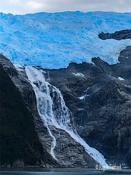 Once that was over, there were a number of events programmed such as the trip sum-up by the expedition team, showing us their favourite photos from this voyage, the Captain's farewell cocktail party, at which one of the passengers, an American who happened to be staying in the cabin next to mine, sang a song for us called Los Pinguinos, whose music and lyrics, he later told me, had been written by two Jewish-American women, Zina Goldrich and Marcy Heisler. It was quite entertaining.
After dinner we got to preview the 40:07 minute end-of-trip video, which is posted below. I have found myself in my knitted Canada hat at minute 17 being handed a pole to the right of the screen as I wade through the water from the zodiac and step onto the beach at Stromness Bay, South Georgia, and three times around minute 34: twice photographing the Lemaire Channel in my black puffy jacket, and the other once again picking up a pole and testing it on the rocks before climbing onto Petermann Island in Antarctica. Let me know if you see me elsewhere in it and don't forget to turn on the sound track with its dramatic music! Saturday, March 21, 2026: Punta Arenas - Santiago, Chile and Sunday, March 22, 2026: Santiago, Chile to Victoria, B.C. (48.4284° N, 123.3656° W) via Toronto, ON, Canada
 The trip was over and we were told to vacate our cabins by 8:00 a.m. after leaving our large suitcases by the elevators by 10:30 p.m. last night. Taken in four groups onto buses, we were given a short tour of Punta Arenas, this time travelling first to the top of the city for an overview of the metropolis and then to the main square for the statue of Magellan and the chance to rub the foot of the Indian, which reportedly meant that we would be back in Punta Arenas in our lifetime. I had been curious to visit this square ever since I had come across its mention in another book I translated, this time from French, published in February 2025 and called Heartquake by Sophie Rouzier. Without spoiling the plot, I can tell you that the protagonist flies to Antarctica from Punta Arenas to take part in the southernmost marathon in the world. According to Wikipedia, the Antarctica Marathon, first held in January, 1995, is a “42.195-kilometre (26 mi 385 yd) race ... held on King George Island, one of the largest Antarctic Islands just off the Antarctic Peninsula. There is also a half-marathon held at the same time. The start and finish is at Bellingshausen Station (the Russian base), and the course passes the Artigas Base (Uruguayan), the Frei Base (Chilean) and the Great Wall Base (Chinese). The race route follows a gravel road connecting the stations and changes each year according to their operations as well as road and weather conditions.”
Finally we were driven to the airport where our bags had already been checked in for us. It was the same chartered plane that we had come in and which had delivered a new group of passengers for the next voyage, this one going to the Falklands and Antarctica only but then travelling further south which meant that the crew, expedition team, and about 65 passengers would hope to see Emperor Penguins (the only species that had eluded us this time). Our plane sat on the tarmac for three hours with us in it because, we were told, there was something wrong with the plane's system. Instead of moving us to one or more commercial flights or having another charter plane sent down from Santiago, they decided to wait until the original plane had been repaired. The task finally completed, we took off and arrived safely in Santiago three hours later than scheduled. Luckily, I still had a two-hour (reduced from five) lay-over in Santiago between my flights, so I was able to get to my Santiago to Toronto plane on time after working on my computer in the business lounge. I found that I had been upgraded to business, at my request, for both this flight and the next (from Toronto to Victoria), so was actually able to eat well and sleep well before my arrival, although due to headwinds (according to the flight attendant, although the captain never communicated anything about our lateness), we arrived in Victoria an hour after the scheduled arrival. To my surprise, I still managed to get to the concert I had flown all this way to attend.    |
All rights reserved. Website © Angela Fairbank 2005-2026.
|